

RADAR
-
Bill McClure
- Chief Steward
- Posts: 56
- Joined: Fri Dec 16, 2005 11:50 am
- Sailboat: MacGregor 26X
- Location: Seattle/Olympia WA
RADAR
Interesting article in this month's 48 North about installing radar in a 26X. http://content.yudu.com/A1v3bg/48NJan12 ... ipbook.swf Total cost about $3K.
-
mastreb

- Admiral
- Posts: 3927
- Joined: Wed Feb 09, 2011 9:00 am
- Sailboat: MacGregor 26M
- Location: Cardiff by the Sea, CA ETEC-60 "Luna Sea"
- Contact:
Re: RADAR
Great article, although IMHO a chartplotter would have solved the specific problem (fog) that caused them to buy a radar. Not much chance of hitting anyone when everyone else would have been home 

-
Phil M

- Captain
- Posts: 807
- Joined: Sun Jun 08, 2008 9:29 am
- Sailboat: Other
- Location: 44' Jeanneau, Saskatoon, SK, Canada
Re: RADAR
I think on the east coast, thick fog is more a regular occurrence, especially in the spring or fall months. If one were to regularly cross shipping lanes in those foggy conditions he encountered in the article, radar could save the day!
For my Mac, and where I sail, probably overkill.
thanks for the magazine link!
Phil M
For my Mac, and where I sail, probably overkill.
thanks for the magazine link!
Phil M
Re: RADAR
It is something that you would want when you are sailing most at the time when the fogs are up and there is some great danger of hitting another boat.
But the cost is something that could make you look past this radar, but I bet that it will really look good when you have it installed already. I just hope that it will be a great working one as well.
But the cost is something that could make you look past this radar, but I bet that it will really look good when you have it installed already. I just hope that it will be a great working one as well.
-
Bill McClure
- Chief Steward
- Posts: 56
- Joined: Fri Dec 16, 2005 11:50 am
- Sailboat: MacGregor 26X
- Location: Seattle/Olympia WA
Re: RADAR
Yes, the 3K price tag is a bit stiff. I thought I'd topped out on mods with a 1K composting toilet.
Radar would be a nice thing to have here in Puget sound. Fog season starts in August, which is about the only month we don't have a lot of rain. After that-it's dark most of the time, or raining, or both. While a chart plotter is a great thing (next mod, here I come), I think they installed the radar for the things that don't show up on charts-other boats. There are enough commercial shipping, fishing, logging and big power boats around here that go out in all weather so that you could get run down.
As an example, Canadian ferry took out a big power boat a few years ago in good visibility. I'm not sure what the final verdict was other than the power boat didn't yield right of way. I've heard of people being distracted by their instruments and running into things. Could be urban legend.
The other X in my marina has radar. I haven't asked him much about it. I think the display is down on the table. He put it in after an episode in the fog. I know I've had enough times the GPS has failed that I would want some backup for low visibility situations. I just read that the Loran system is going to be maintained as an alternate to GPS in case of problems-natural or otherwise.
-
Bill McClure
- Chief Steward
- Posts: 56
- Joined: Fri Dec 16, 2005 11:50 am
- Sailboat: MacGregor 26X
- Location: Seattle/Olympia WA
Re: RADAR
Hi Phil,
A handheld GPS would be at lot cheaper except it does something entirely different from but complimentary to radar. You can navigate with either, but GPS won't help you avoid collisions in low visibility or with things that aren't charted, like other boats. If I understand correctly, GPS gives you a calculated position based on timing signals from satellites. If you have a chartplotter, that position is displayed on a chart based on measurements made by survey. A number of things can go wrong with GPS. #1 is no power. I don't know about you, but I've come to expect the batteries to be dead in my handheld more often than not. I carry 3 set of spares. Cheap insurance. #2 No signal. Seems the satellites are subject to plenty of interference from natural and manmade sources including deliberate jamming. Apparently it's not to hard to do. They are also out of good position on occasion. I've had a couple of times I couldn't get a signal. 1213 is solar maximum, so expect some problems. #3 hardware/software problems. The extra WAAS satellites in the system can cause problems for older units that are set for lower numbers of satellites. There are also incidents where a whole series of units go wonky on particular dates from programming errors, etc. Then there is good old corrosion. #4 Chart errors. Charts are only as good as the information on them. Some of the charts here in the PNW are based on the original surveys done by Cook and Vancouver in the 1790's. Darn good surveys they were considering the guys just had a rowboat and a sextant. US charts are really, really good, but the difference between GPS position and chart position based on old surveys can cause problems. I understand it can be miles off in some parts of the world. In short, GPS with a chartplotter shows you where you are in theory in a more or less accurate model of the world. It's not the real world. It's amazingly good, but it's not perfect by any means.
Radar (and here I'm not talking from experience. We should have Frank Mighetto tell us about his radar) works like a sonar depthfinder. The waves go out, reflect back, the black box turns it into an outline of the reflections. Real world, real time measurements. It shows what is there instead of just what's charted. Useful for navigation in low/no visibility. A great backup or alternative to GPS. Collision avoidance would seem to be most useful part for a trailer sailor. The new radars are said to be able to pick up low floating objects, like trees, that are a problem here in the sound. I never run WOT for fear of taking out the prop on some barely submerged stump. I don't sail much at night or in fog or rain more for fear of being hit by another boat than running aground. There are plenty of stories of boats using Radar colliding with other boats, the Andrea Doria being one, so it's no guarantee. But I'd feel a lot more comfortable negotiating the early morning fog we often have here with radar going along with the GPS instead of just GPS alone. That fishing boat full of hungover guys going 20 knots isn't on the chart, and you can't expect them to see or hear you in the fog with their boom box, cell phone, and Ipod going.
All that said, $3K is a lot of money for a mod. I don't see myself getting one any time soon. But, we can expect the price to keep coming down. I'd be interested to hear from other people what kind of radar reflectors they have on their boats. Sailboats are notoriously poor radar targets. I've asked ferry boats via VHF on occasion if they could pick me up. It was about 50/50 in perfect conditions with different reflectors.
-
mastreb
- Admiral
- Posts: 3927
- Joined: Wed Feb 09, 2011 9:00 am
- Sailboat: MacGregor 26M
- Location: Cardiff by the Sea, CA ETEC-60 "Luna Sea"
- Contact:
Re: RADAR
Sure, radar is superior to a chartplotter for close navigation because it is real time information. But $3000 is a lot of money for what will be a rarely used item for most Mac owners, whereas chartplotters are used constantly. Also for people who trailer a radar complicates rigging considerably.
I just had to navigate in the fog for the first time last week, as I didn't get back in to the shelter island public docks before the fog rolled over bay. Going into it was scary and there's a lot of small boat traffic, but the GPS got me right back to my slip, and at 3 knots there's plenty of time to correct mistakes.
I just had to navigate in the fog for the first time last week, as I didn't get back in to the shelter island public docks before the fog rolled over bay. Going into it was scary and there's a lot of small boat traffic, but the GPS got me right back to my slip, and at 3 knots there's plenty of time to correct mistakes.
-
Billy
- First Officer
- Posts: 439
- Joined: Tue Jan 06, 2004 3:50 pm
- Location: Dunn NC 2001-26X140 "XX"(DoubleCross)
Re: RADAR
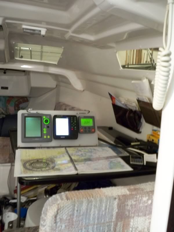
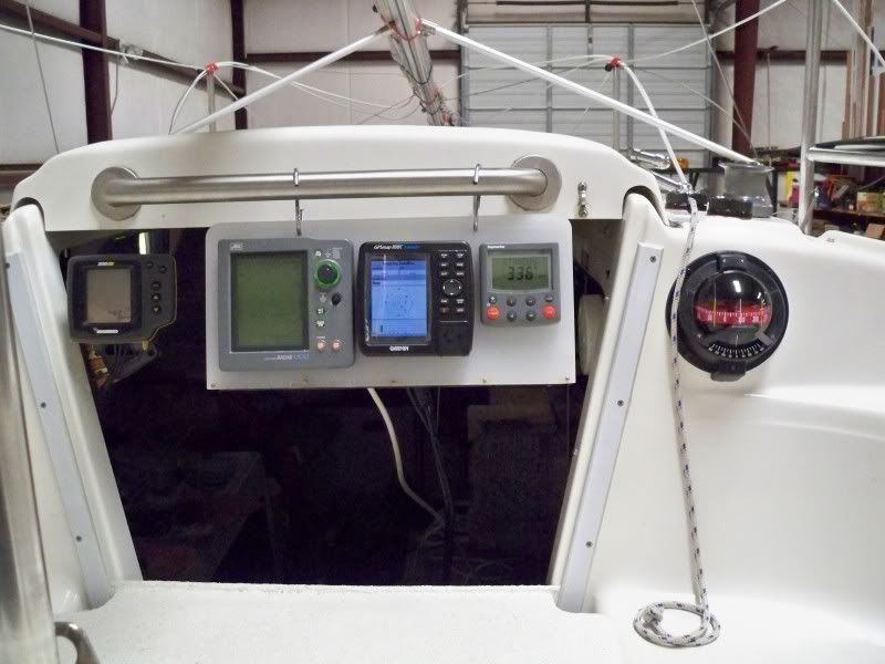
Radar was one of the first mods I did to my X in '01 and I've never regretted it. I made a mount out of stainless steel that attaches to the mast at the holes for the mast raising. If I decide to use it, it takes less than 2 minutes to set the radome and secure the cord. The screen is mounted next to the chartplotter & A/P control on a panel that can be set on the dinette or in the cockpit.
Radar allows you to see rather than be seen. It'll put you in a mooring area on a moonless night and show you the other boats there. It'll show an approaching storm or squall. Give you the distance on any target and the co-ords if tied to the GPS. (At night, one would be surprised just how often some boats don't run lights.) And with the guard zone on, an audible alarm will let you know if anything gets near--under sail or at anchor. Makes you feel a lot easier going below while underway.
Since I single hand my boat, it's a piece of equipment I feel is necessary. Without radar, I'd have to change the way, where & when I sail.


-
Billy
- First Officer
- Posts: 439
- Joined: Tue Jan 06, 2004 3:50 pm
- Location: Dunn NC 2001-26X140 "XX"(DoubleCross)
Re: RADAR
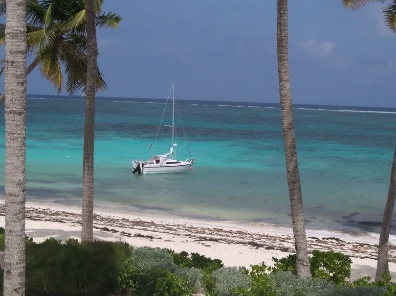
Thanks. Another use for one of the Walmart cutting boards. I ripped about 1/3 off at about 30*. (I really should learn to measure.lol) After doing the cutouts for the instruments, I flipped the the narrow panel over and screwed the 2 pieces together with brass screws forming a miter joint. It stands on its own. Also appplied foam on the bottom to prevent sliding. I made some hooks to hang it from the hatch grab rail, but sitting on the bench/ac box seems to be the best location outside.Québec 1 wrote:Hey Billy ..that's one nice instrument cluster!
Q1

-
Doupirate
- Chief Steward
- Posts: 74
- Joined: Wed Dec 07, 2011 10:45 am
- Sailboat: MacGregor 26M
- Location: Chicoutimi, Quebec, Canada
Re: RADAR
I have two independant units of these
http://www.gemplers.com/product/145261/ ... S?pfx=OPWP
with two independant sets of Blue Water maps, about 100 way-points in, plus a third non-map E-trex and paper maps with routes all plotted on.
I also have this:
http://www.findmespot.ca/en/index.php?cid=101
Here is my crew:

In fog, I can rely on my ears and on this, transmitting blind once in a while:


My antenna is at the top of the mast and I also have a 6 watts handheld VHF.
With a standard radar reflector, I believe I reasonnably cover the risks for unintended fog sailing at 12 hours from shores.
You might have noticed I favor redundancy....
http://www.gemplers.com/product/145261/ ... S?pfx=OPWP
with two independant sets of Blue Water maps, about 100 way-points in, plus a third non-map E-trex and paper maps with routes all plotted on.
I also have this:
http://www.findmespot.ca/en/index.php?cid=101
Here is my crew:
In fog, I can rely on my ears and on this, transmitting blind once in a while:
My antenna is at the top of the mast and I also have a 6 watts handheld VHF.
With a standard radar reflector, I believe I reasonnably cover the risks for unintended fog sailing at 12 hours from shores.
You might have noticed I favor redundancy....
Last edited by Doupirate on Mon Jan 16, 2012 7:28 am, edited 1 time in total.
-
Kittiwake
- First Officer
- Posts: 255
- Joined: Wed Nov 23, 2011 7:34 pm
- Sailboat: MacGregor 26M
- Location: BC, Canada
Re: RADAR
Nice setup Doupirate. That planned trip to the islands off the Gaspe Peninsula should be amazing. Not many people get to do that.
I have little experience with fog. But on one of my trips this summer I underestimated my time and traveled for hours after dark in a light drizzle and low overcast. I held my Garmin GPSMap 76Cx (with chart chip for local waters) in one hand while steering through narrow (rocky!) tidal passages and a few rips with the other. It worked surprisingly well in that one could keep track of both the water depth and the shoreline on the same screen. The somewhat disconcerting part was having to stare into the gloom ahead for floating debris (and of course crab & prawn traps). I was lucky that the water surface was quite smooth: the trip was exhilarating.
I was however left thinking that an awful lot depended on my one GPS. At a few points I could have anchored for the night if necessary, but it would have been awkward if the instrument had failed. I wonder how many of us carry duplicate navigation electronics.
Kittiwake