

Grey Nomad yarns
Re: Grey Nomad yarns
Hi ya Nautek...the total of our panels is 180 watt...6 x 20 on a curved frame across the stern at above head height...used to be a radar tower on a Bertram...cut narrow and new feet on top of the cockpit combing...and one Chinese made 60w flexible panel stuck to the sliding cabin hatch....but we don't often see the total wattage produced...it's been a bit disappointing with a maximum ampereage reaching 7-8 amps.I guess the orientation to the sun is not optimal...earlier thought of the panels keeping up to our fridge are possibly premature although just had 11 days (Jan) on the Hawkesbury River and still had frozen food going home so can't be to bad...had thought to use motor for topup charging but lighting coil in our new 15hp Suzuki not up to continuous duty and burned out...bummer...!!!
-
Nautek

- First Officer
- Posts: 253
- Joined: Mon Jul 14, 2008 2:55 am
- Sailboat: MacGregor 26X
- Location: Tingoora, Queensland, Australia ~ "MacSea"
Re: Grey Nomad yarns
Hi Bartmac
Finding a place to put panels is a big problem on a small boat
I am still thinking wind generator
Still undecided
Would you have a photo of your setup?
Allan
Finding a place to put panels is a big problem on a small boat
I am still thinking wind generator
Still undecided
Would you have a photo of your setup?
Allan
-
Clemo
- Engineer
- Posts: 142
- Joined: Sat Dec 29, 2007 3:51 pm
- Sailboat: MacGregor 26X
- Location: Batemans Bay, NSW, Australia
Re: The Mac with no mast.
I met a couple in Batemans Bay a couple of years ago who had left the mast at home.
They used the boat as a caravan but took it of the trailer and moored overnight. They might have had a dog.
With a boat ramp in most coastal towns they camped for free right in the middle of town and no hastle with pets in van parks. They might have done the Murray the same way.
Might be the same folk.
C ya.
-
Oskar 26M

- First Officer
- Posts: 411
- Joined: Sun Mar 23, 2008 10:04 pm
- Sailboat: MacGregor 26M
- Location: Perth Australia, 2007 26M, 60hp E-tec
Re: Grey Nomad yarns
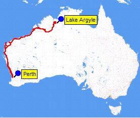
I'm grey enough and have some nomadic tendencies, so I guess our Perth-Lake Argyle trip last weekend. Although we've done nothing in comparison to Boblee, we have now completed a few trips using my  Oskar as a cruising yacht and/or caravan.
We started small with cruises from Jervoise Bay (Cockburn Sound WA) to Garden, Penguin and Rottnest Is and found the very comfortable for a few days to a couple of weeks on the water.
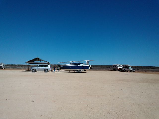
Once we upgraded the trailer to take the necessary weight, we ventured a little further, first to Jurien Bay, then Shark Bay, using the as both a caravan and cruising yacht. The works well as a caravan provided you don't mind clambering through that narrow transom access area. (I have some mods in mind that should improve on that.)
Last weekend we returned from our longest yet: - a 6-weeks trip from Perth to Lake Argyle and return.
It was a very long trip. Pressure of work also meant that it was also late in the season to be heading north. However, we set a leisurely pace on the way up, stopping off at Northampton, Carnarvon, Coral Bay, Exmouth, Onslow, Dampier, Sandfire, Cable Beach (Broome), Fitzroy Crossing, Turkey Creek then finally Lake Argyle Village, then a week on the Lake itself. We only did a day trip to Wyndham, and spent a couple of days in Kununurra, then returned stopping in Fitzroy Crossing, 2 days in Derby, a few days in an air-conditioned Cable Beach apartment (to recuperate from the Derby heat) then straight back to Perth with over-night stops at Peawah River, Minilya, and Murchison River (Galena Bridge).
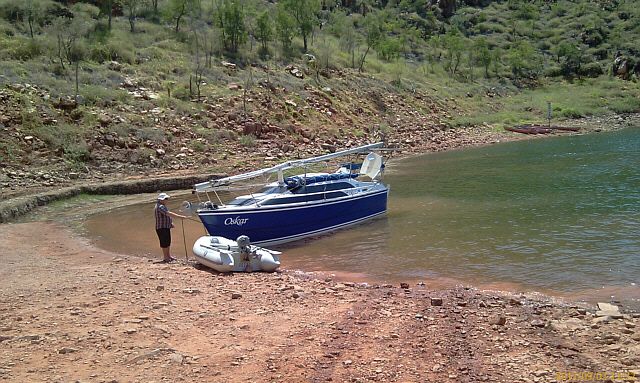
We passed through many beautiful places with some desolate places along the way (Oskar at Lyndon River enroute to Coral Bay).
There are great launching facilities in most of the places we visited but we were single minded about getting to the lake so only launched once, at Exmouth .
We were rewarded by having a large shark tail the boat for about an hour. It just criss-crossed astern of the boat, presumably waiting for fish scraps but it was a bit unnerving when you are several miles offshore in Exmouth Gulf. However, the shark gave up after a while and we relaxed, drifting along at 1-2 kts in very light winds. Very peaceful!
We were startled back to reality by a very loud whooshing sound from not far astern of the boat. Sure enough, a (very large) humpback whale and calf had surfaced, probably less than 100 metres away and was heading straight for us. We were in the 'no go' whale-watching zone (dead ahead of them), so did the prudent thing, started the motor to let her know we we there and moved out of her way.
Although we enjoyed other stop-overs, we didn't launch again until we got to THE LAKE.
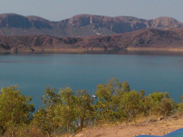
And what a Lake it is! I had read the stats and seen some photographs, it was only after sailing on it that I gained any real appreciation of:
• just how huge the Lake is;
• the astonishing extent of avian and aquatic wildlife and fish;
• the stunningly spectacular scenery;
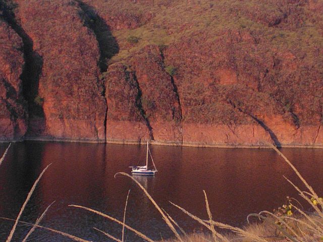
Oskar moored in Bamboo Cove adjacent to Banangum Ridge showing Lake's high water mark
Oskar in Bamboo Cove near sunset
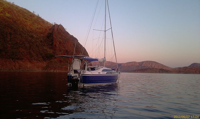
Oskar with Coolibah Pocket in the background.
We decided to take a couple of organised cruises to familiarise ourselves with the Lake and glean some local knowledge from the cruise skippers. These cruises covered about 50 nm. I highly recommend both cruises on Lake Argyle and the GPS tracks recorded by OziExplorerCE on my phone were useful for understanding the available charts and for creating safe waypoints.
• Greg from Lake Argyle Cruises has very extensive local knowledge and was very helpful, allowing us to use his spare mooring as a base.
• Graham from Triple J Tours was also very knowledgeable and helpful.
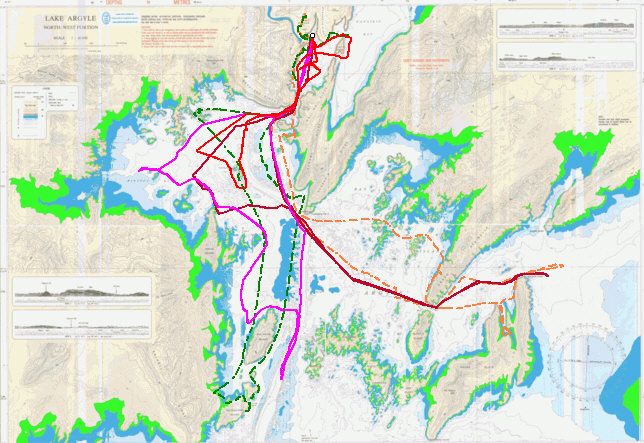
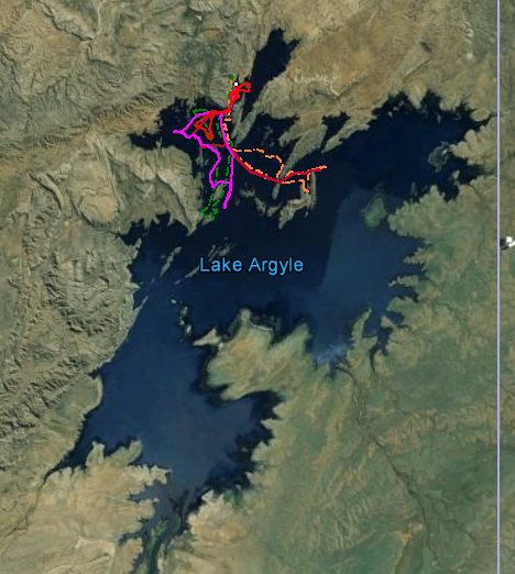
We only managed 70-odd nautical miles of cruising around the “inner" (northern reaches) of Lake Argyle on Oskar, as shown by our tracklogs on the Lake Argyle Chart.
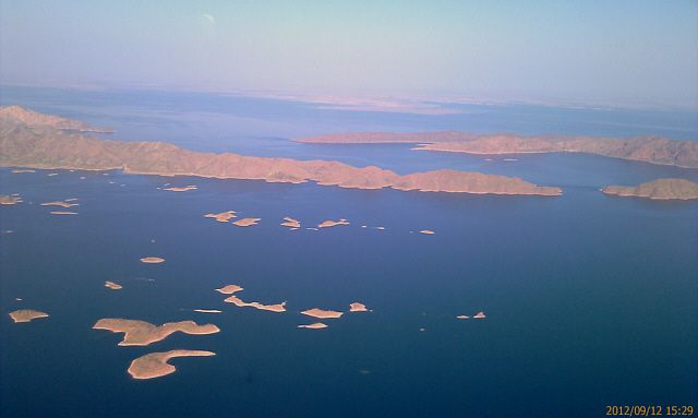
However, this aerial photo from our flight over the Lake showing the Bay of Islands, Hicks Passage and Hagan Island with the 'main lake' in the distant background and plotting our tracklogs on a Google-Earth image of the whole Lake shows that we barely scratched the its surface! Nowhere near as extensive as Bosun Bob's and other journeys.
Before the trip, I also had no idea that Lake Kununurra is so big! Had time permitted we would have loved to have launched Oskar on it. Instead, we took the commercial 55 km trip down Lake Kununurra, which we thoroughly enjoyed. But a word of caution for prospective sail-boats: Lake Kununurra is crossed by some VERY LOW overhead power lines.
The only significant downsides of our trip were:
• The smoke from the numerous bushfires. According to the locals, most of them were deliberately lit. We encountered significant fires from Fitzroy Crossing onwards, and had to dive through fire-fronts near Mary's Poole and on the way to and from Wyndham. The night after the above photo was taken of Oskar moored in Bamboo Cove we saw one fire lit, allegedly by some French backpackers camped at the end of the Cove. The fire quickly spread up the surrounding hillsides and threatened both the Lake Argyle Village and the restored Durack Homestead Museum. Banangum Ridge (behind the boat in the photo) was completely burnt out the following night – very sad for the rock wallabies, and other wildlife that lived there.
• Launching and retrieval went well enough, despite the very primitive "boat ramp". The "ramp" is simply a leftover rocky construction track designed for mega dump trucks. It was by far the worst ramp we saw on the entire trip, made worse by the commercial fishermen "power-loading" when retrieving their boats – WA's Water Corporation should be ashamed of themselves for not upgrading the ramp and sealing or even occasionally grading the rocky access road.
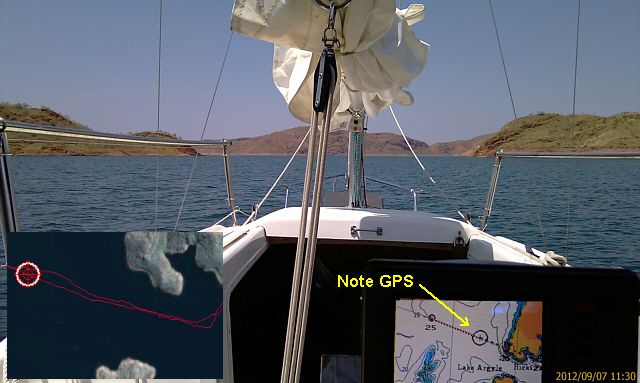
• The inaccurate nautical chart and local info that people have knocked the leg off their powerboats on uncharted rocky pinnacles made navigation a bit of an issue. The nautical chart of the Lake was drawn by WA's then Public Works Department in 1982. It is still being sold and has also made its way into GPS systems (my Seiwa GPS uses C map which includes the chart). I gather that the chart was derived from earlier topographic maps of the area. It is a very detailed chart but unfortunately is incorrectly geo referenced, so the chart features are shown about 120 metres East and 40 metres South of where they are in reality. Hence it was not uncommon to have the GPS showing us going across land when in fact we were in water 40 metres deep. Conversely, if we were relying on the GPS it would be telling us that we should be in 40 metres of water in the middle of the old river bed, when in fact we would be trying to sail across a rocky headland! This example (Hicks passage and GPS), the photo shows us approaching the middle of the passage, while the GPS is showing us on a collision course with Dravo Peninsula. The inset shows our tracklogs and position according to Google Earth.
• It was too late in the season and was starting to get very hot, especially in the last week when temperatures were approaching the 40's. Despite deploying Oskar's oversized boom tent plus a reflective tarp to protect that "heat-sponge" created by the foredeck's black stripes and windows, as well as improvising an evaporative cooling system with fans, towels and buckets of water, the cabin was intolerable most of the day, and barely tolerable at night. I've since been looking through the Aircon mods on this forum.
In summary was it worth the 8000 km round trip? Absolutely YES!
Would I do it again? Definitely YES!
However:
• I would go earlier in the year, not so close to the end of the dry season and hope to avoid the fires, smoke, and the strong winds blowing off the Northern Territory.
• I would also like to take a lot more time.
• I would plan to spend several weeks on the Lake exploring the eastern and southern reaches and I'd like to explore Lake Kununurra as well;
• If I had more time, I'd like to spend much more time on the water along the way at:
• Shark Bay
• Carnarvon
• Exmouth and Ningaloo Reef;
• Onslow;
• Dampier and
• Point Sampson.
Oh yes and
• I would probably invest in a small aircon unit and upgrade my generator from 1 to 2 kva to run it. Some creature comforts are important.
Ahh the dreams of a wannabe grey nomad....
We started small with cruises from Jervoise Bay (Cockburn Sound WA) to Garden, Penguin and Rottnest Is and found the
Once we upgraded the trailer to take the necessary weight, we ventured a little further, first to Jurien Bay, then Shark Bay, using the
Last weekend we returned from our longest yet: - a 6-weeks trip from Perth to Lake Argyle and return.
It was a very long trip. Pressure of work also meant that it was also late in the season to be heading north. However, we set a leisurely pace on the way up, stopping off at Northampton, Carnarvon, Coral Bay, Exmouth, Onslow, Dampier, Sandfire, Cable Beach (Broome), Fitzroy Crossing, Turkey Creek then finally Lake Argyle Village, then a week on the Lake itself. We only did a day trip to Wyndham, and spent a couple of days in Kununurra, then returned stopping in Fitzroy Crossing, 2 days in Derby, a few days in an air-conditioned Cable Beach apartment (to recuperate from the Derby heat) then straight back to Perth with over-night stops at Peawah River, Minilya, and Murchison River (Galena Bridge).
We passed through many beautiful places with some desolate places along the way (Oskar at Lyndon River enroute to Coral Bay).
There are great launching facilities in most of the places we visited but we were single minded about getting to the lake so only launched once, at Exmouth .
We were rewarded by having a large shark tail the boat for about an hour. It just criss-crossed astern of the boat, presumably waiting for fish scraps but it was a bit unnerving when you are several miles offshore in Exmouth Gulf. However, the shark gave up after a while and we relaxed, drifting along at 1-2 kts in very light winds. Very peaceful!
We were startled back to reality by a very loud whooshing sound from not far astern of the boat. Sure enough, a (very large) humpback whale and calf had surfaced, probably less than 100 metres away and was heading straight for us. We were in the 'no go' whale-watching zone (dead ahead of them), so did the prudent thing, started the motor to let her know we we there and moved out of her way.
Although we enjoyed other stop-overs, we didn't launch again until we got to THE LAKE.
And what a Lake it is! I had read the stats and seen some photographs, it was only after sailing on it that I gained any real appreciation of:
• just how huge the Lake is;
• the astonishing extent of avian and aquatic wildlife and fish;
• the stunningly spectacular scenery;
Oskar moored in Bamboo Cove adjacent to Banangum Ridge showing Lake's high water mark
Oskar in Bamboo Cove near sunset
Oskar with Coolibah Pocket in the background.
We decided to take a couple of organised cruises to familiarise ourselves with the Lake and glean some local knowledge from the cruise skippers. These cruises covered about 50 nm. I highly recommend both cruises on Lake Argyle and the GPS tracks recorded by OziExplorerCE on my phone were useful for understanding the available charts and for creating safe waypoints.
• Greg from Lake Argyle Cruises has very extensive local knowledge and was very helpful, allowing us to use his spare mooring as a base.
• Graham from Triple J Tours was also very knowledgeable and helpful.
We only managed 70-odd nautical miles of cruising around the “inner" (northern reaches) of Lake Argyle on Oskar, as shown by our tracklogs on the Lake Argyle Chart.
However, this aerial photo from our flight over the Lake showing the Bay of Islands, Hicks Passage and Hagan Island with the 'main lake' in the distant background and plotting our tracklogs on a Google-Earth image of the whole Lake shows that we barely scratched the its surface! Nowhere near as extensive as Bosun Bob's and other journeys.
Before the trip, I also had no idea that Lake Kununurra is so big! Had time permitted we would have loved to have launched Oskar on it. Instead, we took the commercial 55 km trip down Lake Kununurra, which we thoroughly enjoyed. But a word of caution for prospective sail-boats: Lake Kununurra is crossed by some VERY LOW overhead power lines.
The only significant downsides of our trip were:
• The smoke from the numerous bushfires. According to the locals, most of them were deliberately lit. We encountered significant fires from Fitzroy Crossing onwards, and had to dive through fire-fronts near Mary's Poole and on the way to and from Wyndham. The night after the above photo was taken of Oskar moored in Bamboo Cove we saw one fire lit, allegedly by some French backpackers camped at the end of the Cove. The fire quickly spread up the surrounding hillsides and threatened both the Lake Argyle Village and the restored Durack Homestead Museum. Banangum Ridge (behind the boat in the photo) was completely burnt out the following night – very sad for the rock wallabies, and other wildlife that lived there.
• Launching and retrieval went well enough, despite the very primitive "boat ramp". The "ramp" is simply a leftover rocky construction track designed for mega dump trucks. It was by far the worst ramp we saw on the entire trip, made worse by the commercial fishermen "power-loading" when retrieving their boats – WA's Water Corporation should be ashamed of themselves for not upgrading the ramp and sealing or even occasionally grading the rocky access road.
• The inaccurate nautical chart and local info that people have knocked the leg off their powerboats on uncharted rocky pinnacles made navigation a bit of an issue. The nautical chart of the Lake was drawn by WA's then Public Works Department in 1982. It is still being sold and has also made its way into GPS systems (my Seiwa GPS uses C map which includes the chart). I gather that the chart was derived from earlier topographic maps of the area. It is a very detailed chart but unfortunately is incorrectly geo referenced, so the chart features are shown about 120 metres East and 40 metres South of where they are in reality. Hence it was not uncommon to have the GPS showing us going across land when in fact we were in water 40 metres deep. Conversely, if we were relying on the GPS it would be telling us that we should be in 40 metres of water in the middle of the old river bed, when in fact we would be trying to sail across a rocky headland! This example (Hicks passage and GPS), the photo shows us approaching the middle of the passage, while the GPS is showing us on a collision course with Dravo Peninsula. The inset shows our tracklogs and position according to Google Earth.
• It was too late in the season and was starting to get very hot, especially in the last week when temperatures were approaching the 40's. Despite deploying Oskar's oversized boom tent plus a reflective tarp to protect that "heat-sponge" created by the foredeck's black stripes and windows, as well as improvising an evaporative cooling system with fans, towels and buckets of water, the cabin was intolerable most of the day, and barely tolerable at night. I've since been looking through the Aircon mods on this forum.
In summary was it worth the 8000 km round trip? Absolutely YES!
Would I do it again? Definitely YES!
However:
• I would go earlier in the year, not so close to the end of the dry season and hope to avoid the fires, smoke, and the strong winds blowing off the Northern Territory.
• I would also like to take a lot more time.
• I would plan to spend several weeks on the Lake exploring the eastern and southern reaches and I'd like to explore Lake Kununurra as well;
• If I had more time, I'd like to spend much more time on the water along the way at:
• Shark Bay
• Carnarvon
• Exmouth and Ningaloo Reef;
• Onslow;
• Dampier and
• Point Sampson.
Oh yes and
• I would probably invest in a small aircon unit and upgrade my generator from 1 to 2 kva to run it. Some creature comforts are important.
Ahh the dreams of a wannabe grey nomad....
-
cruiser
- Engineer
- Posts: 134
- Joined: Wed Aug 04, 2010 8:44 pm
- Sailboat: MacGregor 26S
- Location: Brisbane, Australia. "Myuna" Macgregor 26S, 8HP Nissan outboard
Re: Grey Nomad yarns
Great write up Oskar. Thanks for giving us all something to dream about - must be a great part of Australia to visit - bit like the Nth Qld of 40 ago.
-
Boblee
- Admiral
- Posts: 1702
- Joined: Thu Aug 10, 2006 5:08 am
- Location: Berrigan, Riverina Australia boatless at present
Re: Grey Nomad yarns
HAH Oskar
You mentioned on the other thread that you had a seperate thread on Lake Argyle but couldn't find it until you posted the link, I had obviously gone to Nyngan and then never saw it as a fresh topic as I usually only read new posts bugger.
Will try and get back later today to read it properly thank's a great report, agree about the GPS though but it's fairly common and after a while you learn to use it as a reference only, spent a lot of time travelling on dry land according to the gps (Navionics).
-
Nautek
- First Officer
- Posts: 253
- Joined: Mon Jul 14, 2008 2:55 am
- Sailboat: MacGregor 26X
- Location: Tingoora, Queensland, Australia ~ "MacSea"
Re: Grey Nomad yarns
Oskar
Great story
As for the GPS
topo maps can be compiled useing a different chart datum to marine charts
In saying that you can apply the offsets in your GPS to make it all right if you know the amount of the offset
On marine charts the offsets are documented if they apply but not sure about topo maps
Also do you travel with your solar panels in place or do you fold them up?
Allan
-
Oskar 26M
- First Officer
- Posts: 411
- Joined: Sun Mar 23, 2008 10:04 pm
- Sailboat: MacGregor 26M
- Location: Perth Australia, 2007 26M, 60hp E-tec
Re: Grey Nomad yarns
Hi Allan
Mounting solar panels is a big problem for trailering.
I take my solar panels off for road travel, partly because they stick out the back a bit far, but mostly because the combination of their weight being magnified by road travel shocks and the lift effect generated by the savage vortex created by some passing road trains would put a lot of strain on the davit mountings.
On this trip I put the panels on the car's roof rack with an umbilical cord leading back to the boat to keep the freezer running. It worked okay but despite all my efforts I couldn't get ropes tight enough to hold firm when some trucks hurtled by, and I ended up having to use ratchet straps to tie the panels tightly to the rack.
On a previous long haul trip I mounted the panels as bat wings on 1" stainless steel tubing 'safety rails' clamped between the cabin top stanchions (you can see the rails in the link to my pic of GPS problems). The panels were attached by U bolts so that they could be rotated around the rails for road travel, then horizontally when on the water. It worked, but wind effects again put huge strain on the mountings. I could see how much the panels flapped around when trucks went by and on that trip I ended up taking the panels off and transporting them in the cabin.
I have yet to find a satisfactory solution, so let me know if you do!
cheers
Gordon
-
Mac26Mpaul

- Admiral
- Posts: 1066
- Joined: Mon Jun 14, 2010 2:36 am
- Sailboat: MacGregor 26M
- Location: Gold Coast, Australia 26M "Little Annie" Etec 50