

Leon
Farallon Islands
-
delevi

- Admiral
- Posts: 2184
- Joined: Fri May 06, 2005 1:03 am
- Location: San Francisco Catalina 380, former 26M owner
- Contact:
Farallon Islands
Trying to psyche myself up for a run to the Farallon Isles. I read that it gets nasty past the continental shelf. There is a book I’m reading called “Devil’s Teeth” which describes all the gruesome details about the sea conditions and the sharks… but it isn’t shark season yet. I am fascinated to see this place. I know I must do this, even though everyone I talk to and everything I read says that it's a brutal passage and yes, I’m a bit nervous. Expecting 8-12 foot swells every 12 seconds with 3 foot wind waves and possible 3 foot cross swell. Wind 15-25 knots. We'll probably have a crew of 4-6. Still waiting for others to confirm. Three ladies for rail meat and two buddies to work the sheets, though all of their sailing experience is sailing with me. PFDs and water proof clothing will be worn by all at all times. We’re planning to spend Friday night moored at Angel Island, start early Saturday morning and head out through the Golden Gate. It is 30 miles off the coast of San Francisco and the whole trip needs to be done in one day since the islands are inaccessible and there is no safe anchorage. Only a handful of scientists and millions of birds inhabit the islands. It is illegal for civilians to set foot on them. We will attempt to do the whole thing under sail, hopefully averaging 7 knots… should be doable with the wind velocity, but not sure about the sea state. Should be beating the whole way there with a westerly heading and NW winds. Will be broad reach on the way back. We’ll motor all or part of the way back if we’re not making good time to get back to the bay before dark. Of course, if conditions are really bad or something comes up in the forecast which I feel is too dangerous, the whole deal is off and we’ll all have to take a rain check. Wish me luck 
Leon
Leon

-
KEVIN'S OWN

- Deckhand
- Posts: 42
- Joined: Tue Apr 25, 2006 5:03 pm
- Location: Douglaston, NY
-
Bill Warnock

- Deckhand
- Posts: 27
- Joined: Sun Nov 27, 2005 11:49 am
- Sailboat: MacGregor 26M
- Location: Southern Calif '04 M Honda 50
- Contact:
>I’m a bit nervous.<
Yes Leon... I would be also... and understandably so..!
Then again you know your Mac quite well by now... relative
to it's blue water capabilities much less shortcomings... and
that area up there that is your sailing environment.
The only thing I took exception to... was your crew complement.
For an undertaking of this type I would probably want no more
than one or at the most two crewmembers aboard... besides me.
But that is my personal opinion... which is based on a very
limited knowledge of the Mac and its characteristics in blue
water/coastal cruising at this point in time.
And yeh... when reading your post... the Jim Gray
incident flashed through my mind. His passage was very
simular to your proposed undertaking. But I do believe he
experienced excellant conditions and his demise is not
necessarily related to foul weather and/or heavy sea problems.
Wish you the very best... and should you actually do this "round"
it will make for one heck of a "sea story"... when you get back.
Bill
Channel Islands Harbor
Oxnard, California
-
Night Sailor

- Admiral
- Posts: 1007
- Joined: Mon Dec 26, 2005 4:56 pm
- Sailboat: MacGregor 26X
- Location: '98, MACX1780I798, '97 Merc 50hp Classic, Denton Co. TX "Duet"
Voyage prep for Farallones
I've only sailed SF Bay, not offshore, but I would think the best trip pland not only would include the weather, but departure and arrival times would take into consideration also using the tide changes to one's speed advantage.
I do not know the topography of the bottom near the Farallones, but I've been told the ocean is a lot less lumpy once past the 100 fathom curve. That coast however, has several places where undulations of the bottom from seamounts and rifts or canyons cause the surface to be confused, especially in a brisk counter wind, much like the Caribbean in places.
Do have a plan for fog navigation and ship avoidance. Take more fuel than you think you need in case of rig failure.
File a float plan upon leaving with the USCG.
I would recommend no more than a total of four crew; three plus you. Be certain all are sure they are not going to get seasick and become burdens rather than help.
Rent the latest EPIRB device from WM in the event of a serious emergency. The cost is very reasonable.
Give us all a detailed report upon returning, with pictures if possible.
-
Bill Warnock
- Deckhand
- Posts: 27
- Joined: Sun Nov 27, 2005 11:49 am
- Sailboat: MacGregor 26M
- Location: Southern Calif '04 M Honda 50
- Contact:

I dont know the area you will be sailing in...but would you have sea room enough for a drogue or sea anchor in case of a problem getting back the same day...with a crew of 4 on board it shouldnt be a problem with sleeping arrangements if you had to spend the night out...so I'd take sleeping bags just in case......and enough food...and water...
-
Frank C
Leon, you've already heard my view of this destination ... considering the ROI, why bother! I think I linked you to a couple personal cruise stories from larger commercial boats. One related that the trip waters were so rough she couldn't eat lunch. And upon arrival at the islands, the stench of animal life and bird residue was so great ... she still couldn't eat. But, a couple of added comments.
- I agree w/those above that your crew is too large. I'd suggest a crew of 3 is ideal, a maximum of 4. The boat's not really big enough for 6, and that crew size raises the CoG too much. As you're aware, the Farallons are one apex of the great white triangle. Along with the coast of Oz, the Farallon triangle is the world's greatest feeding and breeding grounds for the great white shark. Rail meat isn't needed to feed the great whites, but may anyway. (IIRC, the largest of the great whites are about the same length and weight of a Mac~!
 )
) - Idle's suggestion of a drogue is a good idea. After all, if winds are severe, the engine fails and you're being pushed nearer the coast ... the anchor might be useless as an emergency brake!
- Timing your transit for both winds and tides through the Golden Gate ... in a small boat ... twice in the same day ... isn't necessarily easy or advisable. I suggest, again, reading the Mehaffy's book, "Cruising Guide to SF Bay." Their comprehensive info on every Bay and NorCal coastal destination should prove invaluable in planning alternate stops and best times & tides for the Golden Gate.
- The only redeeming benefit to this cruise, IMO, is making the Farallons one leg of a real cruise, probably 4 to 6 days long. I'd choose an overnight anchorage at Drake's Bay as the second leg. Then if really ambitious, I might add Tomales Bay as the third leg (2 days) before returning through the Golden Gate. Planning your transits through the GG for slack tides might dictate a final overnight anchoring at Sausalito or Angel island. Tides and winds might make the Farallons a better final leg, rather than being first.
-
delevi
- Admiral
- Posts: 2184
- Joined: Fri May 06, 2005 1:03 am
- Location: San Francisco Catalina 380, former 26M owner
- Contact:
Bill,I wonder if that is the area that locals call the "Potato Patch"?
No it isn't. The potato patch is a channel just west of the GG Bridge. At times, it looks like white water rapids. This is due to a combination of reefs sucking the water in and confused seas along with a nasty undercurrent. Many sailboats get stuck in this area because they can't get sufficient power to make headway. The coastguard patrols regularly and I personally witnessed two rescues. Once I was in the same situation, approaching the bridge, only to find myself sailing backwards. A coastguard boat pulled up next to me asking if I required assistance. "No sir, we're just fine," I replied as I tilted down the Etec, started her up and we were on our merry way. Love the Mac
Frank,
I knew you were going to chime in with some cautious advice. I understand this is quite an undertaking but I just have to do this.
The latest forecast calls for rain, so this adventure will need to be postponed.
I agree that 6 is too many. I invited two friends and they wanted to bring their wives and of course, Dawn also read the book and wants to make the trip, but really 3-4 would be ideal. Not too worried about the COG with 6 aboard since everyone would be on the windward side, but it does make the cockpit way too crowded, more than just an inconvenience when circumstances call for quick action.
Not sure how much use a drogue would be. Halfway to the islands, the water is no more than 50 feet deep. After that, it drops off to 1,000+ feet. I have to check my charts to see what it's like near the islands but I believe there are plenty of rocks so I don't plan to get closer than 200-300 yards from the isles. Hopefully that's far enough not to get the awful stench.
Frank, I know this is not your idea of the ideal trip but when I reschedule, I would love to have you aboard, so you're welcome to join us. I'll do my best to keep crew size to 3-5 people. Some can be rail meat so as not to crowd the cockpit. The sharks usually don't come out until September
Leon
-
Frank C
But Leon, September-October are the months for best weather! ... share some water with those sharks~ 
Search on "Drake's" to read other accounts of the cruise to Pt. Reyes. In October it's likely to be a mild beat. A flotilla would be great if I had the right crew.
Mod's note: thread moved to Events/Venues ~fc
Search on "Drake's" to read other accounts of the cruise to Pt. Reyes. In October it's likely to be a mild beat. A flotilla would be great if I had the right crew.
Mod's note: thread moved to Events/Venues ~fc
-
delevi
- Admiral
- Posts: 2184
- Joined: Fri May 06, 2005 1:03 am
- Location: San Francisco Catalina 380, former 26M owner
- Contact:
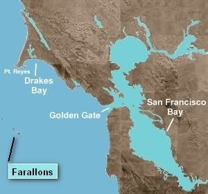
Nice picture Frank. A flotilla does sound nice. Drake's Bay doesn't look much closer to me. Sounds like you actually want to see the sharkies.
Correction on the depths. I posted wrong info. I just looked in my chart book and it looks like the average depth is about 40-50 feet. The continental shelf is west of the Farallons. I guess that's why they call it the Gulf of the Farallons. Duh
Suppose a drogue would be handy, but at that depth, my danforth would probably work just fine
-
Frank C
Leon,
I'll agree with you that average depth shows at 50 to 60, but are you sure you're not reading fathoms instead of feet? Chart 18645 shows that the 10 fathom line is very close to any of the islands. I suppose you could hook a Danforth into that bottom at a 3-scope but, in an emergency I'd rather be trying with a Bulwagga or Rocna. Emergencies aside, as long as you're not opposing an ebb tide from 4 to 7 pm, I guess the homebound reach through the Gate would be safe enough (can't find my Tides book ).
If one could skirt to the north of the Potato Patch, Bolinas Bay actually looks to be a good emergency harbor. It's not "marked" with any anchors though, probably because it's not well-sheltered from the prevailing WNW winds. I haven't looked at the detail chart but it's possible our shallow drafts could sneak into Bolinas Lagoon, for totally sheltered overnight safety.
Drakes Bay is 25 miles north of the Gate, probably 30 miles from Farallon SE. But those 30 miles grant you that very large Bay with total protection from West to SE, also without any of the late afternoon tidal complications into the Gate. Besides that, Drakes is a 'worthy' overnight destination, a primitive anchorage along that beautiful NorCal coastline.
Sir Francis purportedly holed-up there over 4 months to refit the Golden Hinde.
I'll agree with you that average depth shows at 50 to 60, but are you sure you're not reading fathoms instead of feet? Chart 18645 shows that the 10 fathom line is very close to any of the islands. I suppose you could hook a Danforth into that bottom at a 3-scope but, in an emergency I'd rather be trying with a Bulwagga or Rocna. Emergencies aside, as long as you're not opposing an ebb tide from 4 to 7 pm, I guess the homebound reach through the Gate would be safe enough (can't find my Tides book
If one could skirt to the north of the Potato Patch, Bolinas Bay actually looks to be a good emergency harbor. It's not "marked" with any anchors though, probably because it's not well-sheltered from the prevailing WNW winds. I haven't looked at the detail chart but it's possible our shallow drafts could sneak into Bolinas Lagoon, for totally sheltered overnight safety.
Drakes Bay is 25 miles north of the Gate, probably 30 miles from Farallon SE. But those 30 miles grant you that very large Bay with total protection from West to SE, also without any of the late afternoon tidal complications into the Gate. Besides that, Drakes is a 'worthy' overnight destination, a primitive anchorage along that beautiful NorCal coastline.
Sir Francis purportedly holed-up there over 4 months to refit the Golden Hinde.

