

I used to put in at carolina bch state park last year. sailing with the genny only. the river is great for sailing. tons of room for you and cargo ships north of the park.and 8 knots downstream running on 1 sail
Macgregors of Masonboro and Wilmington (NC) - (MOMAW)
-
C Striker

- First Officer
- Posts: 214
- Joined: Sun Nov 16, 2008 8:29 am
- Sailboat: MacGregor 26M
- Location: Wilmington,NC
Re: Macgregors of Masonboro and Wilmington (NC) - (MOMAW)
Opie, What would you consider slack tides for that channel? Just an hour on either side of tide change? I think we were that close to high tide, with the wind blowing in. Coulda just been all the powerboats.
I used to put in at carolina bch state park last year. sailing with the genny only. the river is great for sailing. tons of room for you and cargo ships north of the park.and 8 knots downstream running on 1 sail i hear closer to the mouth can get rough though due to depth.
I used to put in at carolina bch state park last year. sailing with the genny only. the river is great for sailing. tons of room for you and cargo ships north of the park.and 8 knots downstream running on 1 sail
-
opie

- Captain
- Posts: 895
- Joined: Tue Nov 16, 2004 5:40 am
- Sailboat: MacGregor 26X
- Location: Wilmington, NC
Re: Macgregors of Masonboro and Wilmington (NC) - (MOMAW)
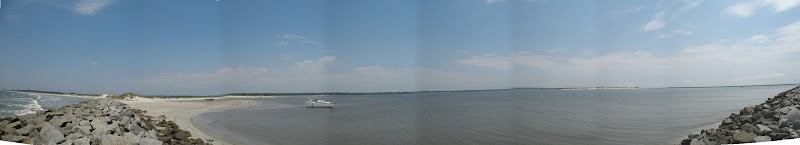
Just got back from our Little River Trip. Here is a one pic, a panorama of the Waties Island place we anchored..... (click for larger image, (I think...))
------ on edit, I did not like the small size of the pics when using Picassa photo service, so I put the pics on my website I am playing with. Pic under "Waties Island" link.
Link Here.....
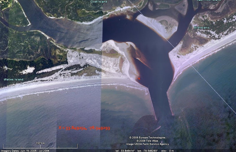
Here is the Google Earth Pic of the same place from the sky view.
Had a great time all week. Up and down the ICW. On the beaches. Nice places. We stayed at Ocean Isle, NC. Food at Calabash is wonderful.
------ on edit, I did not like the small size of the pics when using Picassa photo service, so I put the pics on my website I am playing with. Pic under "Waties Island" link.
Link Here.....
Here is the Google Earth Pic of the same place from the sky view.
Had a great time all week. Up and down the ICW. On the beaches. Nice places. We stayed at Ocean Isle, NC. Food at Calabash is wonderful.
-
Pete
- Engineer
- Posts: 194
- Joined: Fri Jun 08, 2007 12:14 pm
- Sailboat: Venture 2-24
- Location: Wilmington, NC
- Contact:
Re: Macgregors of Masonboro and Wilmington (NC) - (MOMAW)
Looks like I am going to have to do some serious work to my trailer before I go out again. My axle was bent when I got the boat. The one wheel rides a little crooked and compleatly wore the tread off in less then 40 miles.
Pete
Pete
-
opie
- Captain
- Posts: 895
- Joined: Tue Nov 16, 2004 5:40 am
- Sailboat: MacGregor 26X
- Location: Wilmington, NC
Re: Macgregors of Masonboro and Wilmington (NC) - (MOMAW)
I am planning a Cape Lookout trip for the end of the month. Any suggestions from those who have gone before are welcome..... (I will search the archives since I think Chip organized a trip a few years ago to Cape Lookout...)
Here is my start on asking myself questions and doing some preliminary planning. LINK HERE
Here is my start on asking myself questions and doing some preliminary planning. LINK HERE
-
C Striker
- First Officer
- Posts: 214
- Joined: Sun Nov 16, 2008 8:29 am
- Sailboat: MacGregor 26M
- Location: Wilmington,NC
Re: Macgregors of Masonboro and Wilmington (NC) - (MOMAW)
I'm heading out this evening, Friday and coming out Sunday afternoon.
Will most likely be in Banks channel with hopes of a quick first trip into the blue.
I'm considering blasting down the ICW and up the river for the fireworks. Depends on if the Admiral joins me tomorrow morning, or evening. For her, blasting is at 10 knots. Does anyone have a descent guess at how long a trip that is? I know the river portion but not the ICW. Sorry to be a pain but these last minute excersions really put me ina bind. But I do see a slip in store for the C. Striker next summer.
I'll be the goofas without a mailsail attached to my mast, sailing is sailing and it's MillA time!
EC
-
Retcoastie
- Captain
- Posts: 673
- Joined: Sat Sep 16, 2006 7:00 am
- Sailboat: MacGregor 26X
- Location: Gray Hawk, Kentucky 2002 X "Last Flight"
-
C Striker
- First Officer
- Posts: 214
- Joined: Sun Nov 16, 2008 8:29 am
- Sailboat: MacGregor 26M
- Location: Wilmington,NC
Re: Macgregors of Masonboro and Wilmington (NC) - (MOMAW)
Thanks Jack thats great stuff. I'd love to take 4 or 5 days for that trip in mid to late September with the Admiral. How are the near beach anchorages south of the inlet? With a 60 pound boxer I need to get pretty close for the evening and morning adventures over the stern.
Erik
Erik
-
opie
- Captain
- Posts: 895
- Joined: Tue Nov 16, 2004 5:40 am
- Sailboat: MacGregor 26X
- Location: Wilmington, NC
Re: Macgregors of Masonboro and Wilmington (NC) - (MOMAW)
Which inlet? If you mean Beaufort Inlet, there are no anchorages nearby outside. Many on the inside on the back of the Bank. And at Cape Lookout, you can anchor at miles of beaches inside that the dog will love.
ps - after 4 days my boat was covered with 1/16 inch barnacles. I mean even the transom valve was almost white with barnacles. What a difference in the water at Wrightsville.... I have been out ten days there without a single barnacle.
ps - after 4 days my boat was covered with 1/16 inch barnacles. I mean even the transom valve was almost white with barnacles. What a difference in the water at Wrightsville.... I have been out ten days there without a single barnacle.
-
C Striker
- First Officer
- Posts: 214
- Joined: Sun Nov 16, 2008 8:29 am
- Sailboat: MacGregor 26M
- Location: Wilmington,NC
Re: Macgregors of Masonboro and Wilmington (NC) - (MOMAW)
Punkin and I are heading out tomorrow, wet by 6 am and overnighting at or near masonboro. Home by 5 or 6 pm monday. 40% chance of showers will keep us out of the ocean and the temperature down too!
Erik
Erik
-
opie
- Captain
- Posts: 895
- Joined: Tue Nov 16, 2004 5:40 am
- Sailboat: MacGregor 26X
- Location: Wilmington, NC
Re: Macgregors of Masonboro and Wilmington (NC) - (MOMAW)
Local Knowledge is important. You can not trust your GPS chartplotter all the time. Trust your eyes. And don't try new places in the dark if they are dangerous.
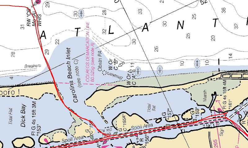
Here is an example for the MOMAW area: (click for larger images)
First, here is my actual logged GPS track when motoring out of Carolina Beach Inlet recently. It is superimposed on the current Coast Guard nav chart. You can see that if you were in the dark and trusted your chartplotter to guide you out of the inlet you would hit the sand for sure.
Second, here is the same GPS actual logged track superimposed on Google Earth. Same thing....... so you can not trust Google Earth either.
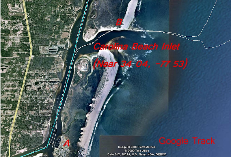
Finally, you may be thinking that my Garmn GPS must be inaccurate? Well, look at this shot (A) of where I went straight in and docked right at the gas pump cabana at the Joyner Marina gas dock to fill up my tanks before I went out the inlet. When I left the gas dock I backed up into the current for a ways before going south to Snow's Cut and then returned to exit the inlet. As you can see, it is very accurate as to the Garmin and Google Earth lining up correctly.
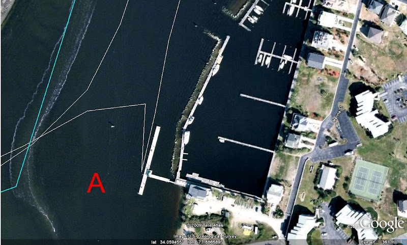
Moral of the story? In sandy inlets without jettys, storms can shift the inlets. The nav charts and Google Earth are not updated all that often. Be careful not to trust your charts more than you own eyes. (Or follow a big fishing boat out and in....... that may be the best way of all.....)
Here is an example for the MOMAW area: (click for larger images)
First, here is my actual logged GPS track when motoring out of Carolina Beach Inlet recently. It is superimposed on the current Coast Guard nav chart. You can see that if you were in the dark and trusted your chartplotter to guide you out of the inlet you would hit the sand for sure.
Second, here is the same GPS actual logged track superimposed on Google Earth. Same thing....... so you can not trust Google Earth either.
Finally, you may be thinking that my Garmn GPS must be inaccurate? Well, look at this shot (A) of where I went straight in and docked right at the gas pump cabana at the Joyner Marina gas dock to fill up my tanks before I went out the inlet. When I left the gas dock I backed up into the current for a ways before going south to Snow's Cut and then returned to exit the inlet. As you can see, it is very accurate as to the Garmin and Google Earth lining up correctly.
Moral of the story? In sandy inlets without jettys, storms can shift the inlets. The nav charts and Google Earth are not updated all that often. Be careful not to trust your charts more than you own eyes. (Or follow a big fishing boat out and in....... that may be the best way of all.....)
-
C Striker
- First Officer
- Posts: 214
- Joined: Sun Nov 16, 2008 8:29 am
- Sailboat: MacGregor 26M
- Location: Wilmington,NC
Re: Macgregors of Masonboro and Wilmington (NC) - (MOMAW)
So True Opie.
My GPS shows me on land more than on water. Biggest waste of money unless out in the ocean with trace path enabled. My wife claims I keep forgetting it in the cabin. I'm not forgetting, just like you said I trust my own eyes more than the screen. Folks do like to watch the cute fish "swim" by though.
We left the Striker anchored at Masonboro last Sunday morning, labor day weekend. After maybe 2 hours on the beach side, we came back to the parking lot that our lonely anchorage had turned into. Not a problem. I was handed my stern anchor and a few guys pushed us out past their boats. Good thing considering the north wind of 20 kt gusting to 25. We were just south of the cove.
How about that M just south of masonboro in a dry slip? Sure looks nice up on a pedistal.
-
opie
- Captain
- Posts: 895
- Joined: Tue Nov 16, 2004 5:40 am
- Sailboat: MacGregor 26X
- Location: Wilmington, NC
Re: Macgregors of Masonboro and Wilmington (NC) - (MOMAW)
Hey locals to Wilmington. I am testing some repairs to my Mac and will be in the water off and on until Dec 15th..... If you are nearby and want to chat or sail (if it is not too cold..) let me know via PM.....
-
cmeperform

- Engineer
- Posts: 107
- Joined: Fri May 23, 2008 11:12 am
- Sailboat: MacGregor 26M
- Location: Tarpon Springs Fl
Re: Macgregors of Masonboro and Wilmington (NC) - (MOMAW)
Snow Cut?Thats where my Mac went airbourne!  Rough sea there sometimes.Not to mention its near the graveyard
of the atlantic,
http://www.coastalguide.com/packet/nc-shipwrecks.shtml
I lived in Southport NC for 4 months a couple of summers ago.
Tarpon springs Florida on the gulf of mexico is a lot better for me.
Be careful over that way,
Craig
of the atlantic,
http://www.coastalguide.com/packet/nc-shipwrecks.shtml
I lived in Southport NC for 4 months a couple of summers ago.
Tarpon springs Florida on the gulf of mexico is a lot better for me.
Be careful over that way,
Craig
-
opie
- Captain
- Posts: 895
- Joined: Tue Nov 16, 2004 5:40 am
- Sailboat: MacGregor 26X
- Location: Wilmington, NC
Re: Macgregors of Masonboro and Wilmington (NC) - (MOMAW)
Hey Masonboro sailors!
The S/V Marin and the S/V Sea Striker got together recently and had a fine time anchoring, swapping sea stories, looking at potential mods and letting the admirals compare notes. Pepper the wonder dog was happy as well.
Here is the Garmin/Google file saved from the sail trip we took on the outside. We went out 3 miles before the winds started topping 15 and we sailed back and dropped sails before returning to the inlet. (Click for larger image) I have to admit here and now that Striker's blue hull was faster than my faded white hull. Oh, well....
(The info of what is under the AR370 buoy is below the picture. Great place to fish, but you have to also consider the rule about dumping no closer than 3 miles, so you can guess what also feed the fish there... haha
We also got to marvel at the 100's of boats that rafted up for the Memorial Day festivities. We sorta stayed on the fringe and observed the crazies.
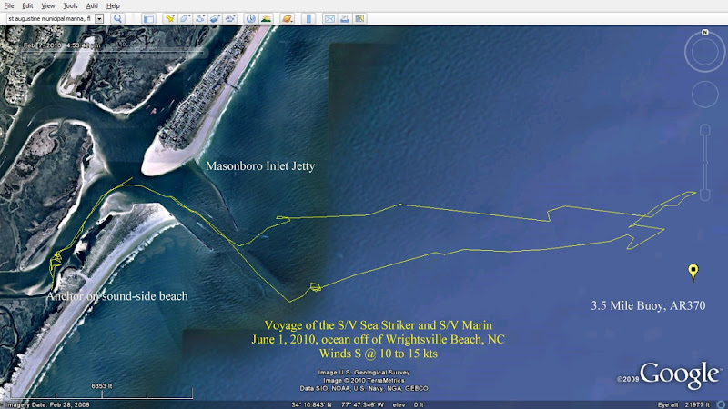
MEARES HARRISS REEF, AR-370, Average Depth: 52'
Buoy Location in GPS ddm: 34° 10.467' / 077° 45.067'
General Location: 100° M, 3.5 nm from the Masonboro Inlet sea buoy
Material, Deployment Date(s), GPS, (Decimal Minutes)
110' tug FIREFIGHTER, 02-Jun-70, 34° 10.490' / 077° 44.990'
50' truck tank, Summer 1972, Position unverified
90' barges: 2, 01-Aug-73, 34° 10.467' / 077° 44.800'
Tires: 56,500, 1973 - 1974, Throughout site
440' Liberty Ship, ALEXANDER RAMSEY, 26-Aug-74, 34° 10.520' / 077° 45.120'
135' barge, 25-Sep-80, 34° 10.483' / 077° 44.783'
120' tug SOCONY 8, 15-Dec-82, 34° 10.533' / 077° 45.083'
105' tug STONE BROTHERS, 14-Jan-83, 34° 10.330' / 077° 44.790'
Concrete pipe: 155 tons, 16-Sep-08, 340 10.454' / 0770 44.950'
The S/V Marin and the S/V Sea Striker got together recently and had a fine time anchoring, swapping sea stories, looking at potential mods and letting the admirals compare notes. Pepper the wonder dog was happy as well.
Here is the Garmin/Google file saved from the sail trip we took on the outside. We went out 3 miles before the winds started topping 15 and we sailed back and dropped sails before returning to the inlet. (Click for larger image) I have to admit here and now that Striker's blue hull was faster than my faded white hull. Oh, well....
(The info of what is under the AR370 buoy is below the picture. Great place to fish, but you have to also consider the rule about dumping no closer than 3 miles, so you can guess what also feed the fish there... haha
We also got to marvel at the 100's of boats that rafted up for the Memorial Day festivities. We sorta stayed on the fringe and observed the crazies.
MEARES HARRISS REEF, AR-370, Average Depth: 52'
Buoy Location in GPS ddm: 34° 10.467' / 077° 45.067'
General Location: 100° M, 3.5 nm from the Masonboro Inlet sea buoy
Material, Deployment Date(s), GPS, (Decimal Minutes)
110' tug FIREFIGHTER, 02-Jun-70, 34° 10.490' / 077° 44.990'
50' truck tank, Summer 1972, Position unverified
90' barges: 2, 01-Aug-73, 34° 10.467' / 077° 44.800'
Tires: 56,500, 1973 - 1974, Throughout site
440' Liberty Ship, ALEXANDER RAMSEY, 26-Aug-74, 34° 10.520' / 077° 45.120'
135' barge, 25-Sep-80, 34° 10.483' / 077° 44.783'
120' tug SOCONY 8, 15-Dec-82, 34° 10.533' / 077° 45.083'
105' tug STONE BROTHERS, 14-Jan-83, 34° 10.330' / 077° 44.790'
Concrete pipe: 155 tons, 16-Sep-08, 340 10.454' / 0770 44.950'