For U.S. waters you don't have to buy charts. You download them free from NOAA....BOAT wrote:
Thanks for clearing that up. I have the free version of openCPN and it has no charts in it without internet. I was not aware you could buy charts for it. .
http://www.charts.noaa.gov/
..... and OpenCPN works with both their RNC and ENC charts (I have both loaded but usually use the RNC ones for a location). You go and download the states you want to have charts for. Their is no charge for OpenCPN or the charts. Now saying that there are some people out there that will sell you a CD with all the charts downloaded onto it and with OpenCPN also loaded. This just saves you the time of doing it yourself but it doesn't take that long to download the charts or the program.
Outside the U.S. if they are available, like the Bahamas, you can buy charts in some cases that will work with OpenCPN and after you install a "plug-in"....
http://opencpn.org/ocpn/downloadplugins
...OpenCPN will display and work with those charts. It is really easier to do than to explain.
Other 'plug-in's' will let you see the AIS targets on the screen and they have a number of others such as the one that allows you to see "google earth" on a split screen and weather and other ones. I only have a few installed but since OpenCPN is an open software and used around the world people are creating new and useful plug-ins all the time so it is an ever expanding chartplotter.
You can use it for trip planning on a larger monitor and download the way points in seconds to about any other chartplotter you might have on board.
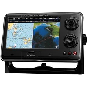
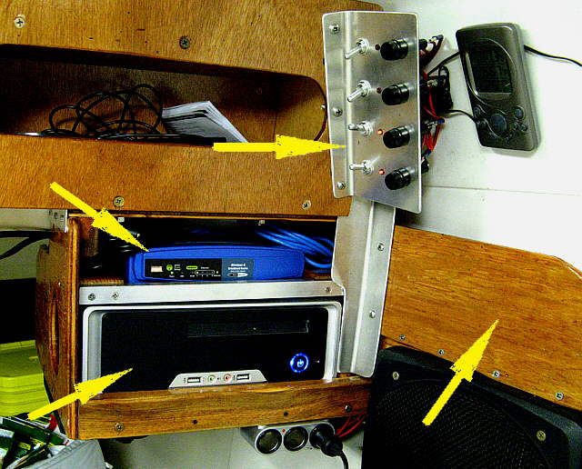
I bought a Standard Horizon CPN700i chartplotter...
http://www.thegpsstore.com/Standard-Hor ... Ahm68P8HAQ
.... but will still run OpenCPN on the boat for route planning and backup, downloading routes from it to the Standard Horizon which will be connected to it on the network. The Standard Horizon has a larger 7 inch screen but the OpenCPN is running on a much larger monitor so I can see a lot more of the chart on it than on the Standard Horizon.
You can still get an AIS transponder it just costs more money ($600-$800). If if was going to take the Mac back to the Bahamas (not going to) or sailing in an area with heavy shipping lane traffic I'd spend the money for one. The Endeavour is much larger so I don't worry quite as much about not being seen by a larger boat on their radar or visually,BOAT wrote:..wanted a radio that would transmit my AIS signal but now I am bummed because you said they don't do that. ...
Sumner
============================
1300 miles to the Bahamas and back -- 2015
The MacGregor 26-S
The Endeavour 37
Trips to Utah, Idaho, Canada, Florida
Mac-Venture Links