

When I go to Door County I trailer to Escanaba, MI. A nice marina, overbuilt so there are always slips available, free trailer parking, and Pizza Hut will deliver right to your boat. Cedar River and Hayward Bay are both south of Escanaba but I haven't launched there.
I then sail to Jackson Harbor on Washington Island.
At Fayette, there had been a hotel with a three-story outhouse, which I found interesting.
Midwest Mac Meeting?
-
Bill at BOATS 4 SAIL
- Admiral
- Posts: 1006
- Joined: Sat Jan 10, 2004 7:28 pm
- Sailboat: MacGregor 26D
- Location: Oconomowoc, WI
-
Mark Prouty
- Admiral
- Posts: 1723
- Joined: Mon Jan 19, 2004 8:52 am
- Location: Madison, WI Former MacGregor 26X Owner
Jeff Ritsema wrote:Mark,
When we launched at Sturgeon Bay there was a large municipal marina with great facilities and a private marina to store the trailor just up the street. Is Ephraim as good? I only remember Ephraim from the water side when we went in there.
Two week trip:Bill at BOATS 4 SAIL wrote:When I go to Door County I trailer to Escanaba, MI. A nice marina, overbuilt so there are always slips available, free trailer parking, and Pizza Hut will deliver right to your boat. Cedar River and Hayward Bay are both south of Escanaba but I haven't launched there. I then sail to Jackson Harbor on Washington Island.
At Fayette, there had been a hotel with a three-story outhouse, which I found interesting.
Ive been thinking about launch sites. Here are some thoughts.
Sturgeon Bay - Nice but farther South than Id like to go for the two week trip.
Ephraim - Ephraim has a public boat launch. Once you launch there, you park your trailer in a field behind the fire station. You then park your car on the public streets.
Escanaba - I like Bills idea of launching at Escanaba.
The reasons I like this launch site are:
Note: Escanaba is only 37 miles farther from the south than Ephraim.
Ill let it sit a few days for discussion before I change the itinerary.
Escanaba
From Escanaba to...
Location .................... L 45 44.7 N; 087 02.2 W
Delta County web site http://www.deltami.org/index.html
City of Escanaba
PO Box 948
Escanaba, MI 49829-0948
Phone: (906) 786-0240
Fax: (906) 786-4755
Email: [email protected]; [email protected]
Website: www.escanaba.org
Contact: Douglas Terry, City Manager Governmental unit
The narrow channel leading into the Escanaba marina on the west shore of Little Bay de Noc offers a welcome respite from the wind and waves. The 200-foot wide channel, protected by trees from the prevailing southwesterly breeze, is used by sailors to furl their sails before hustling out the fenders and docklines. The entrance channel opens up to a 40-acre basin which is the best "hurricane hole" on Green Bay and northern Lake Michigan. There are few harbors which are as well protected from wind, waves, and surges from every direction.
-
Jeff Ritsema

- First Officer
- Posts: 204
- Joined: Tue Sep 28, 2004 10:09 am
- Location: Grand Rapids, Michigan
Mark,
Escanaba sounds like a great spot to go either south to the Door, east to Fayette, or further east to Beaver. As I study the charts, I recall observing most of the boats heading back to Wisc from Beaver passing around the south tip of the island, crossing the approximate 55 nautical miles 0f open water to Rock island or Martin passage.
Here's some ideas:
Escanaba to Fayette: overnight at Fayette
Fayette to St James, Beaver Is (about 70 miles total), weather
permitting, passing around the southern tip of Beaver Island.
Gunkholing among the Beaver Island group for 3 days or so
Back to Washigton Island via the northern route after anchoring at High
Island overnight (slightly shorter open water transit)
Down the Door from there and then back to Escanaba,
Jeff
-
Mark Prouty
- Admiral
- Posts: 1723
- Joined: Mon Jan 19, 2004 8:52 am
- Location: Madison, WI Former MacGregor 26X Owner
-
Mark Prouty
- Admiral
- Posts: 1723
- Joined: Mon Jan 19, 2004 8:52 am
- Location: Madison, WI Former MacGregor 26X Owner


-
Jeff Ritsema
- First Officer
- Posts: 204
- Joined: Tue Sep 28, 2004 10:09 am
- Location: Grand Rapids, Michigan
-
Mark Prouty
- Admiral
- Posts: 1723
- Joined: Mon Jan 19, 2004 8:52 am
- Location: Madison, WI Former MacGregor 26X Owner
Jeff Ritsema wrote:Mark,
Did you have any further thoughts regarding dates for the "midwest rendevous"? This may sound goofy. but I am already setting my next year schedule- not carved in stone, but trying to get some "concrete" ideas.
Thanks, Jeff

I'm going to do the two week trip. I'd like to start July 29th. I'll wait a week before changing the agenda. If there are no responses, I'll make the start date to July 29th. I have no objections to starting a week or two either side of this date. How do others feel?
I'd also like an idea of who is tentatively committed to this trip.
A couple of asides:
* Talk about goofy, I get butterflies just think about this trip.
* Jeff, I can't wait to see your Odin 28
* Half the fun of this trip is planing it.
-
Mark Prouty
- Admiral
- Posts: 1723
- Joined: Mon Jan 19, 2004 8:52 am
- Location: Madison, WI Former MacGregor 26X Owner
Update
I have been working with Jeff Ritsema behind the scenes on this float plan:
What do you think? Feedback desired.
Starting from Manistique Marina:
http://www.manistique.org./marina.html
I talked to Sheila Aldrich - the city manager (906)341-2290. She said that they could accommodate our boats. They have 19 slips that are mostly booked but they have a private dock across the way. In addition, they have dockage on the river's edge and around the Harbor Master's house. The marina has power, showers, pump-outs, fuel and picnic tables. We can park our vehicles and trailers at the Little Bear West Recreational Facility 3 blocks away. The marina is across the street from downtown. It costs $23 a day for a 26 foot boat. The sooner they know the number of people the better.
Start Date - July 22nd:
The cruise will start on July 22nd. This date is the most accommodating to all. We will be starting in Manistique, MI. From Manistique, we will be going out to the Beaver Island group. From the Beaver Island Group, we will be heading to Door County. We will be exploring Door County from Washington Island to Fish Creek. On The way back, we'll stop at Fayette and possibly South River Bay.
Trip Lengths:
I will be taking the full two week cruise. Others have expressed a desire to attend a shorter cruise. This trip might involve up to twelve boats. Those desiring shorter trips can break off anytime and sail back to Manistique as a group. You guys will have to work this out among yourselfs.
The Pack:
For safety, we will be traveling in a pack with boats of varying speeds. All boats might not have big Mac motors. Boats with smaller motors might have to wait a day due to weather to join the main pack. They might have to leave much earlier in the quiet of the early AM to "beat" the weather, or in the late afternoon when the weather has quieted and do a night sail. They will also have longer transit times. At 5mph it mike take up to 7 hours to transit to Beaver from Manistique. The winds of the day on Lake Michigan are usually about 10-11 AM to 4-5 PM; thus, they might begin transit by 3 AM or at 4PM to make a pleasant and safe transit. It's important for at least one boat to accompany slower boats. Since this is all weather related, flexibility is the key. If the weather is threatening and an issue for the slow boats, it will be for the fast boats as well. We will all be "weathered in." Stressing safety is the key especially since small children will be on the trip. Being willing to say no to the marginally safe window of weather is important. It is unlikely but if you get separated from the pack, I have included all GPS positions for each location we will be going.
Communications:
We will be communicating with VHF radios. There will be morning and evening check-ins where all boats will be communicating together at an agreed time. One boat will have to summarize the communications for the plan of the day. I will take on that responsibility but will need the input of others. Jeff Ritsema has experience with this type of expedition and has agreed to share his experiences and help me with this responsibility. I have stolen some of his words for this report.
Roughing it:
Except for two or three nights, we will be near civilization. We will be spending a night at Fayette and possible a night at High Island and South River Bay. Fayette is a state park and from what I understand there are no restaurants and services are limited. We might stay at High Island before crossing to Washington Island. High Island has no accommodations. South River Bay is a beautiful little cove we could anchor at on the way back to Manistique. It also has no services. We will also be spending a night at Jackson Harbor at the end of Door County. At Jackson Harbor, you'll have to take a taxi to a restaurant. I have taken a taxi from there; it was an adventure in itself. With little coaxing, the driver will talk of all sorts of island things.
We will be spending around 3 days at the Beaver Island group. St. James Harbor will be our center of civilization for the area. There are good places to eat there. The Shamrock Bar (231-448-2278) is a famous hangout for the Irish locals and serves lunch and dinner. Newcomers to the island are expected to pay a visit there. Stoney Acres has family style breakfast, lunch, and dinner.
In this area, surrounding islands are only a few miles away from St. James Harbor. People can make their own plans during this time. Some may want to travel out to the surrounding islands and return to St. James for the night. Others might want to anchor out at one of the islands for the night. The islands are close enough that we should be able to communicate no matter where we choose to stay. If one becomes out of range, well still have a rendezvous time at St James Harbor.
Fuel:
There a long stretch from the end of Door County or Washington Island to Manistique. The last stop for Gas is Detroit Harbor until Manistique. We will learn about the range and the distance tolerences of the flotilla as we spend a few days together. If the boats have 25-30 gal of fuel aboard, there should not be any real jeopardy. 20 gal would be minimum to be safe, 25 gal even better.
I carry four gas gas tanks in the cockpit compartments. I also have one strapped in front of the motor. I then carry a smaller dinghy tank in front of the cockpit. It is nothing to step over this tank. The four tanks in the cockpit compartments would be sufficient.

I am looking forward to the moonless nights at the Beaver Island group. The sky on a moonless night is an amazing sight to behold.
What do you think? Feedback desired.
Starting from Manistique Marina:
http://www.manistique.org./marina.html
I talked to Sheila Aldrich - the city manager (906)341-2290. She said that they could accommodate our boats. They have 19 slips that are mostly booked but they have a private dock across the way. In addition, they have dockage on the river's edge and around the Harbor Master's house. The marina has power, showers, pump-outs, fuel and picnic tables. We can park our vehicles and trailers at the Little Bear West Recreational Facility 3 blocks away. The marina is across the street from downtown. It costs $23 a day for a 26 foot boat. The sooner they know the number of people the better.
Start Date - July 22nd:
The cruise will start on July 22nd. This date is the most accommodating to all. We will be starting in Manistique, MI. From Manistique, we will be going out to the Beaver Island group. From the Beaver Island Group, we will be heading to Door County. We will be exploring Door County from Washington Island to Fish Creek. On The way back, we'll stop at Fayette and possibly South River Bay.
Trip Lengths:
I will be taking the full two week cruise. Others have expressed a desire to attend a shorter cruise. This trip might involve up to twelve boats. Those desiring shorter trips can break off anytime and sail back to Manistique as a group. You guys will have to work this out among yourselfs.
The Pack:
For safety, we will be traveling in a pack with boats of varying speeds. All boats might not have big Mac motors. Boats with smaller motors might have to wait a day due to weather to join the main pack. They might have to leave much earlier in the quiet of the early AM to "beat" the weather, or in the late afternoon when the weather has quieted and do a night sail. They will also have longer transit times. At 5mph it mike take up to 7 hours to transit to Beaver from Manistique. The winds of the day on Lake Michigan are usually about 10-11 AM to 4-5 PM; thus, they might begin transit by 3 AM or at 4PM to make a pleasant and safe transit. It's important for at least one boat to accompany slower boats. Since this is all weather related, flexibility is the key. If the weather is threatening and an issue for the slow boats, it will be for the fast boats as well. We will all be "weathered in." Stressing safety is the key especially since small children will be on the trip. Being willing to say no to the marginally safe window of weather is important. It is unlikely but if you get separated from the pack, I have included all GPS positions for each location we will be going.
Communications:
We will be communicating with VHF radios. There will be morning and evening check-ins where all boats will be communicating together at an agreed time. One boat will have to summarize the communications for the plan of the day. I will take on that responsibility but will need the input of others. Jeff Ritsema has experience with this type of expedition and has agreed to share his experiences and help me with this responsibility. I have stolen some of his words for this report.
Roughing it:
Except for two or three nights, we will be near civilization. We will be spending a night at Fayette and possible a night at High Island and South River Bay. Fayette is a state park and from what I understand there are no restaurants and services are limited. We might stay at High Island before crossing to Washington Island. High Island has no accommodations. South River Bay is a beautiful little cove we could anchor at on the way back to Manistique. It also has no services. We will also be spending a night at Jackson Harbor at the end of Door County. At Jackson Harbor, you'll have to take a taxi to a restaurant. I have taken a taxi from there; it was an adventure in itself. With little coaxing, the driver will talk of all sorts of island things.
We will be spending around 3 days at the Beaver Island group. St. James Harbor will be our center of civilization for the area. There are good places to eat there. The Shamrock Bar (231-448-2278) is a famous hangout for the Irish locals and serves lunch and dinner. Newcomers to the island are expected to pay a visit there. Stoney Acres has family style breakfast, lunch, and dinner.
In this area, surrounding islands are only a few miles away from St. James Harbor. People can make their own plans during this time. Some may want to travel out to the surrounding islands and return to St. James for the night. Others might want to anchor out at one of the islands for the night. The islands are close enough that we should be able to communicate no matter where we choose to stay. If one becomes out of range, well still have a rendezvous time at St James Harbor.
Fuel:
There a long stretch from the end of Door County or Washington Island to Manistique. The last stop for Gas is Detroit Harbor until Manistique. We will learn about the range and the distance tolerences of the flotilla as we spend a few days together. If the boats have 25-30 gal of fuel aboard, there should not be any real jeopardy. 20 gal would be minimum to be safe, 25 gal even better.
I carry four gas gas tanks in the cockpit compartments. I also have one strapped in front of the motor. I then carry a smaller dinghy tank in front of the cockpit. It is nothing to step over this tank. The four tanks in the cockpit compartments would be sufficient.
I am looking forward to the moonless nights at the Beaver Island group. The sky on a moonless night is an amazing sight to behold.
-
Bill at BOATS 4 SAIL
- Admiral
- Posts: 1006
- Joined: Sat Jan 10, 2004 7:28 pm
- Sailboat: MacGregor 26D
- Location: Oconomowoc, WI
-
Tony D-26X_SusieQ

- First Officer
- Posts: 306
- Joined: Mon Jan 05, 2004 7:20 am
- Location: Mayo, Maryland

Waste Disposal?
I gather that most of the Mac's will have a porta-pottey that will need to be emptied a few times, will there be facilities to do this?
Larry
Larry
-
Mark Prouty
- Admiral
- Posts: 1723
- Joined: Mon Jan 19, 2004 8:52 am
- Location: Madison, WI Former MacGregor 26X Owner
Manistique, St. James Harbor, Detroit Harbor, Sister Bay, and Ephraim have marinas that have pump-outs.
I have never been in a position where I had to empty a porta-pottey at a marina. I have been able to waited until I got home.
Anybody know the standard operating procedure for dumping a porta-pottey at a marina?
I have never been in a position where I had to empty a porta-pottey at a marina. I have been able to waited until I got home.
Anybody know the standard operating procedure for dumping a porta-pottey at a marina?
-
Mark Prouty
- Admiral
- Posts: 1723
- Joined: Mon Jan 19, 2004 8:52 am
- Location: Madison, WI Former MacGregor 26X Owner
If you are planing on taking this cruise, please sign-in.
Here is the latest itinerary.
2 week trip
Start Date: July 22nd
We will start in Manistique, MI.


Leave Manistique and sail the 35 miles out to St. James Harbor on Beaver Island. Explore the Beaver Island group for a few days.
Travel the 55 miles to Jackson Harbor on Washington Island - explore the area including Rock Island
Travel 24 miles to the Ephram, Chambers Island, Horse Shoe Island, Shanty Bay Area with a possible stop in Sister Bay.
Travel 45 miles to Fayette
Travel 15 miles to South River Bay
Travel 18 miles to Manistique.
Manistique
Location .................. L 45 56.6' N; �086 14.8' W
From Manistique to...
 Mackinac Island 68 miles E
St. James Harbor 35 miles ESE
Jackson Harbor 43 miles SW
Escanaba 54 miles WSW
Port Inland 19 miles E
Beaver Island Group 33 miles (25 miles open water)
Manistique, located at the north end of Lake Michigan at the mouth of the Manistique River, is the only major port along the north shore of the Lake between the northern entrance of Green Bay and the Straits of Mackinac. The harbor offers excellent protection under all weather conditions - good docking facilities and anchorage areas are available. Because of its relatively remote location this interesting town is less often visited compared to other harbors on the lake. It is a complete small city and an excellent place to provision.
ANCHORAGE
The Coast Pilot states that the outer basin is not adapted for anchorage but, in fact, pleasure craft do anchor behind the outer breakwaters. Protection would be limited in heavy weather out of the south or southeast.
DOCKAGE
A Michigan State Waterways Commission marina has accommodations for 18 transient vessels. It is located on the east side of the river 0.3 miles above the mouth, just downstream of the Highway 2 bridge. In approaching this marina, one may encounter current velocities of up to 3 mph. Depths in the marina are limited. In 2004, the depth at the fuel dock was 6 feet. However, 3-4 feet depths were in the river just before the turn into the marina. Depths at docking wells are said to decrease as
one moves east from the first well. Deep-draft boats may want to call ahead for current conditions.
FACILITIES
The fuel dock has a gasoline pump (diesel can be trucked in if necessary). Pumpout and electricity are available. Restroom and shower facilities are on the premises. There is no laundry in the marina, but a laundromat is available 2 blocks away. There is a large playground and picnic facility in the marina area. The business district begins about one
block from the marina. There are both fast food and conventional restaurants within easy walking distance - Topos is especially recommended. Pharmacies, a grocery store, hardware, and sports stores are all conveniently located. Schoolcraft County maintains a modern hospital and airport. Web site: www.manistique.org.
ST. JAMES HARBOR
Location................... L 45 44.6 N; �085 30.5 W
From St. James to...
Mackinac Island 45 miles E
Harbor Springs 28 miles SE
Charlevoix 32 miles S
South Manitou Island 56 miles S
Rock Island Passage 65 miles SW
High Island 4 miles W
Manistique 33 miles NW
Beaver Island, principal member of the Beaver Island group, is approximately 13 miles long, north and south, 3.25 miles wide at the north end, and 6.5 miles wide at the south end, with an area of 53 square miles. Maximum elevation above Lake Michigans water is 200 feet, but most of the island is only about 80 feet high. The island is generally wooded, with bluffs on its west side and lower sloping shores elsewhere; however, Beaver lacks the bold western bluffs and areas of blowing sand that characterize the other large Lake-Michigan islands. St. James Harbor is at the northerly end of the east shore, and the village of St. James on the shores of the harbor is home for almost all of the Islands yeararound population. Summer cottages are found all around the shores of the island. St. James can be the hub of a fine cruising ground. Short and possibly overnight trips and return can be taken to the nearby islands - High and Garden and Hog. Going or coming between Mackinac Island and the ports on Lake Michigan, this makes a good layover spot.
JACKSON HARBOR
Location .................... L 45 24.2' N; 086 51' W
From Jackson Harbor to...
Washington Harbor 4 miles W
Detroit Harbor 11 miles S
Baileys Harbor 32 miles SE
Fayette 22 miles N
Escanaba 23 miles NW
Ephraim 24 miles SW
Jackson Harbor is a quaint harbor on the northeast shore of Washington island that affords shelter from all winds. Although the deeper part of the harbor is partly exposed to winds from north clockwise to east, the anchorage is protected from seas in all directions. This is a quaint fishing harbor with a marine museum, nature trail and beach.
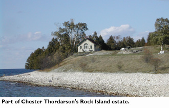
ROCK ISLAND
Location ................. L 45 24.6' N; 087 49.8' W
From Rock Island to
Jackson Harbor 1 mile SW
There is enough water for several boats to tie up inside the dock adjacent to the large boat house.
Ephram
Location ................. L 45 09.6' N; 087 10.4' W
Several docks are available on Ephraims waterfront, and the snug anchorages of Shanty Bay and Horseshoe Island are but a few minutes away. Free Showers
From Ephraim to...
Sturgeon Bay 25 miles S
Fish Creek 6 miles SW
Sister Bay 4 miles NW
Horseshoe Island 1.5 miles W
Several docks are available on Ephraims waterfront, and the snug anchorages of Shanty Bay and Horseshoe Island are but a few minutes away. Eagle Harbor, which is about 2 miles long and l mile wide, is protected from all winds from northeast clockwise to northwestwide open to north and northwest winds except behind the docks. In northwest blows, Horseshoe Island offers excellent protection.
CHAMBERS ISLAND
Location ......................L 45 12' N; 087 21.3' W
From Chambers to...
Menominee 12 miles W
Sturgeon Bay 24 miles S
Fish Creek 9 miles SE
Ephraim 10 miles E
Detroit Harbor 24 miles NE
The principal harbor is on the north shore providing protection except for winds from NNW to ENE. There are other anchorages on the east, west and south shores if the winds are adverse to the north shore anchorage.
HORSESHOE ISLAND
Location ...................L 45 10.6' N; 087 12.7' W
From Horseshoe to...
Eagle Bluff Light, 1 mile SW
Fish Creek 3.5 miles SSW
Ephraim 2 miles SE
Sister Bay 4 miles NE
Horseshoe Island is a fine little harbor of refuge. The harbor is perfectly protected from winds west through north to east and fairly well sheltered from all others. However, it may be uncomfortable in very strong southeast winds, from which Shanty Baya half mile south by westwill afford protection.
SHANTY (Nicolet) BAY
Location .................... L 45 10' N; 087 13.3' W
From Shanty Bay to...
Horseshoe Island 0.75 miles NE
Sturgeon Bay 25 miles S
Escanaba 36 miles N
This attractive anchorage is known locally as Shanty Bay. It is about 2 miles from Ephraim and 5 miles from Fish Creek.
Shanty Bay, Horseshoe Island, and Ephraim are close together, and in one of the three, shelter may be found from any wind. Generally, Shanty Bay offers protection from southerlies; Horseshoe from northerlies; Ephraim from easterlies; and both Horseshoe and Shanty Bay from westerlies.
FISH CREEK
Location ......................L 45 08' N; 087 14.7' W
From Fish Creek to...
Sturgeon Bay 19 miles S
Egg Harbor 5 miles S
Horseshoe Island 3.5 miles N
Ephraim 5 miles N and E
Menominee 16 miles W
Water, gasoline, oil, and ice at the Town dock and Alibi docks. Provisions of all kinds are available in stores in the nearby business area. Two grocery stores are within walking distance of the marina, making Fish Creek a good port for provisioning along this shore.
SISTER BAY
Location ...................L 45 11.5' N; 087 07.3' W
From Sister Bay to...
Ephraim 4 miles S
Horseshoe Island 4 miles SW
Ellison Bay 6 miles N
Free Showers.
The village of Sister Bay has a village dock. It is located on the southeast shore of Sister Bay Harbor and is close to restaurants, drugstore, hardware store, service station, night entertainment, and other public facilities. Slip rental is available, with a dock master on duty (VHF 9, or phone 920-854-4457). Heads, showers, electricity, and water available. This is a well-protected harbor in all conditions, designed to reduce the surge for which this harbor was formerly notorious in northwest winds.
SOUTH RIVER BAY
Location.................. L 45 45.5 N; �086 37.4 W
From South River Bay to
Nahma 5 miles N
Fayette 1 mile S
Washington Harbor 22 miles S
Manistique 18 miles
South River forms a beautiful secluded and unspoiled yacht anchorage, affording good shelter from all winds. The north part of the bay is open to winds from the SW to NW, but the arm in the southwest corner of the bay defeats even these winds. There is but one cottage on the shore of the bay (with a small boat dockprivate), and one on the river. South River Bay is a popular fishing spot and a good location to observe osprey and eagles. The river is interesting to explore in a dinghy, especially with oars or a pole.
FAYETTE, MICHIGAN
(SNAIL-SHELL HARBOR)
From Fayette to...
Detroit Harbor 30 miles S
Washington Harbor 22 miles S
Escanaba 24 miles W
Lake Michigan (Poverty Island Passage), 18 miles
ANCHORAGE
Anchoring is difficult due to the weeds and mud bottom, and there is not much room; however, with perseverance a heavy anchor may be set. Winds north to northwest will bring a surge into the harbor.
DOCKS
A 300-foot dock is available along the west side of the harbor, and a smaller dock is available at the tip of the point in the harbor. These docks are maintained by the Fayette State Park, and "boat-camping" is allowed. Docking rules are posted. The dock is often quite crowded, but most boats will let other boats raft off of them (the weekends are particularly
crowded). The Park charges for overnight tieup$0.55 per foot in 2002, less if rafted off. Checkout time is 3 pm. Note that generators must be shutdown between 2200 and 0700.
SERVICES
The docks offer no servicesneither electricity nor water, though a water faucet is near the dock. The Visitors Center has running water and modern toilet facilities available during the hours it is openphone 906-644-2711. There is a pay telephone at the Park road entrance (about 1 mile from the dock). The Park has a rustic campsite about 0.5 miles from the docks. A beautiful sandy beach is another 0.5 mile walk south past the campground. There are changing rooms at the beach areawell worth the walk! In addition, there are more than 5 miles of hiking trails in the Park, some of which overlook the harbor. The Park Rangers are friendly to boaters. Near the docks in the old town of Fayette, many buildings have been restored and are open to the public. Horsedrawn carriage tours of this town site are available. A use-permit and fee are required for scuba diving in the harborall submerged artifacts are to remain in place and nothing is to be removed from the harbor bottom. The grocery store in Garden (K-Los) will deliver to the dock (906-644-7111). The nearest restaurant is Sherrys Port Bar, south of the swimming beach on the county road.
Here is the latest itinerary.
2 week trip
Start Date: July 22nd
We will start in Manistique, MI.
Leave Manistique and sail the 35 miles out to St. James Harbor on Beaver Island. Explore the Beaver Island group for a few days.
Travel the 55 miles to Jackson Harbor on Washington Island - explore the area including Rock Island
Travel 24 miles to the Ephram, Chambers Island, Horse Shoe Island, Shanty Bay Area with a possible stop in Sister Bay.
Travel 45 miles to Fayette
Travel 15 miles to South River Bay
Travel 18 miles to Manistique.
Manistique
Location .................. L 45 56.6' N; �086 14.8' W
From Manistique to...
Manistique, located at the north end of Lake Michigan at the mouth of the Manistique River, is the only major port along the north shore of the Lake between the northern entrance of Green Bay and the Straits of Mackinac. The harbor offers excellent protection under all weather conditions - good docking facilities and anchorage areas are available. Because of its relatively remote location this interesting town is less often visited compared to other harbors on the lake. It is a complete small city and an excellent place to provision.
ANCHORAGE
The Coast Pilot states that the outer basin is not adapted for anchorage but, in fact, pleasure craft do anchor behind the outer breakwaters. Protection would be limited in heavy weather out of the south or southeast.
DOCKAGE
A Michigan State Waterways Commission marina has accommodations for 18 transient vessels. It is located on the east side of the river 0.3 miles above the mouth, just downstream of the Highway 2 bridge. In approaching this marina, one may encounter current velocities of up to 3 mph. Depths in the marina are limited. In 2004, the depth at the fuel dock was 6 feet. However, 3-4 feet depths were in the river just before the turn into the marina. Depths at docking wells are said to decrease as
one moves east from the first well. Deep-draft boats may want to call ahead for current conditions.
FACILITIES
The fuel dock has a gasoline pump (diesel can be trucked in if necessary). Pumpout and electricity are available. Restroom and shower facilities are on the premises. There is no laundry in the marina, but a laundromat is available 2 blocks away. There is a large playground and picnic facility in the marina area. The business district begins about one
block from the marina. There are both fast food and conventional restaurants within easy walking distance - Topos is especially recommended. Pharmacies, a grocery store, hardware, and sports stores are all conveniently located. Schoolcraft County maintains a modern hospital and airport. Web site: www.manistique.org.
ST. JAMES HARBOR
Location................... L 45 44.6 N; �085 30.5 W
From St. James to...
Beaver Island, principal member of the Beaver Island group, is approximately 13 miles long, north and south, 3.25 miles wide at the north end, and 6.5 miles wide at the south end, with an area of 53 square miles. Maximum elevation above Lake Michigans water is 200 feet, but most of the island is only about 80 feet high. The island is generally wooded, with bluffs on its west side and lower sloping shores elsewhere; however, Beaver lacks the bold western bluffs and areas of blowing sand that characterize the other large Lake-Michigan islands. St. James Harbor is at the northerly end of the east shore, and the village of St. James on the shores of the harbor is home for almost all of the Islands yeararound population. Summer cottages are found all around the shores of the island. St. James can be the hub of a fine cruising ground. Short and possibly overnight trips and return can be taken to the nearby islands - High and Garden and Hog. Going or coming between Mackinac Island and the ports on Lake Michigan, this makes a good layover spot.
JACKSON HARBOR
Location .................... L 45 24.2' N; 086 51' W
From Jackson Harbor to...
Jackson Harbor is a quaint harbor on the northeast shore of Washington island that affords shelter from all winds. Although the deeper part of the harbor is partly exposed to winds from north clockwise to east, the anchorage is protected from seas in all directions. This is a quaint fishing harbor with a marine museum, nature trail and beach.
ROCK ISLAND
Location ................. L 45 24.6' N; 087 49.8' W
From Rock Island to
There is enough water for several boats to tie up inside the dock adjacent to the large boat house.
Ephram
Location ................. L 45 09.6' N; 087 10.4' W
Several docks are available on Ephraims waterfront, and the snug anchorages of Shanty Bay and Horseshoe Island are but a few minutes away. Free Showers
From Ephraim to...
Several docks are available on Ephraims waterfront, and the snug anchorages of Shanty Bay and Horseshoe Island are but a few minutes away. Eagle Harbor, which is about 2 miles long and l mile wide, is protected from all winds from northeast clockwise to northwestwide open to north and northwest winds except behind the docks. In northwest blows, Horseshoe Island offers excellent protection.
CHAMBERS ISLAND
Location ......................L 45 12' N; 087 21.3' W
The principal harbor is on the north shore providing protection except for winds from NNW to ENE. There are other anchorages on the east, west and south shores if the winds are adverse to the north shore anchorage.
HORSESHOE ISLAND
Location ...................L 45 10.6' N; 087 12.7' W
From Horseshoe to...
Eagle Bluff Light, 1 mile SW
Fish Creek 3.5 miles SSW
Ephraim 2 miles SE
Sister Bay 4 miles NE
Horseshoe Island is a fine little harbor of refuge. The harbor is perfectly protected from winds west through north to east and fairly well sheltered from all others. However, it may be uncomfortable in very strong southeast winds, from which Shanty Baya half mile south by westwill afford protection.
SHANTY (Nicolet) BAY
Location .................... L 45 10' N; 087 13.3' W
From Shanty Bay to...
This attractive anchorage is known locally as Shanty Bay. It is about 2 miles from Ephraim and 5 miles from Fish Creek.
Shanty Bay, Horseshoe Island, and Ephraim are close together, and in one of the three, shelter may be found from any wind. Generally, Shanty Bay offers protection from southerlies; Horseshoe from northerlies; Ephraim from easterlies; and both Horseshoe and Shanty Bay from westerlies.
FISH CREEK
Location ......................L 45 08' N; 087 14.7' W
From Fish Creek to...
Water, gasoline, oil, and ice at the Town dock and Alibi docks. Provisions of all kinds are available in stores in the nearby business area. Two grocery stores are within walking distance of the marina, making Fish Creek a good port for provisioning along this shore.
SISTER BAY
Location ...................L 45 11.5' N; 087 07.3' W
From Sister Bay to...
Free Showers.
The village of Sister Bay has a village dock. It is located on the southeast shore of Sister Bay Harbor and is close to restaurants, drugstore, hardware store, service station, night entertainment, and other public facilities. Slip rental is available, with a dock master on duty (VHF 9, or phone 920-854-4457). Heads, showers, electricity, and water available. This is a well-protected harbor in all conditions, designed to reduce the surge for which this harbor was formerly notorious in northwest winds.
SOUTH RIVER BAY
Location.................. L 45 45.5 N; �086 37.4 W
From South River Bay to
South River forms a beautiful secluded and unspoiled yacht anchorage, affording good shelter from all winds. The north part of the bay is open to winds from the SW to NW, but the arm in the southwest corner of the bay defeats even these winds. There is but one cottage on the shore of the bay (with a small boat dockprivate), and one on the river. South River Bay is a popular fishing spot and a good location to observe osprey and eagles. The river is interesting to explore in a dinghy, especially with oars or a pole.
FAYETTE, MICHIGAN
(SNAIL-SHELL HARBOR)
ANCHORAGE
Anchoring is difficult due to the weeds and mud bottom, and there is not much room; however, with perseverance a heavy anchor may be set. Winds north to northwest will bring a surge into the harbor.
DOCKS
A 300-foot dock is available along the west side of the harbor, and a smaller dock is available at the tip of the point in the harbor. These docks are maintained by the Fayette State Park, and "boat-camping" is allowed. Docking rules are posted. The dock is often quite crowded, but most boats will let other boats raft off of them (the weekends are particularly
crowded). The Park charges for overnight tieup$0.55 per foot in 2002, less if rafted off. Checkout time is 3 pm. Note that generators must be shutdown between 2200 and 0700.
SERVICES
The docks offer no servicesneither electricity nor water, though a water faucet is near the dock. The Visitors Center has running water and modern toilet facilities available during the hours it is openphone 906-644-2711. There is a pay telephone at the Park road entrance (about 1 mile from the dock). The Park has a rustic campsite about 0.5 miles from the docks. A beautiful sandy beach is another 0.5 mile walk south past the campground. There are changing rooms at the beach areawell worth the walk! In addition, there are more than 5 miles of hiking trails in the Park, some of which overlook the harbor. The Park Rangers are friendly to boaters. Near the docks in the old town of Fayette, many buildings have been restored and are open to the public. Horsedrawn carriage tours of this town site are available. A use-permit and fee are required for scuba diving in the harborall submerged artifacts are to remain in place and nothing is to be removed from the harbor bottom. The grocery store in Garden (K-Los) will deliver to the dock (906-644-7111). The nearest restaurant is Sherrys Port Bar, south of the swimming beach on the county road.
Midwest Trip
I am a PO of a 26X. I have owned 3 Macs over the last 15 years and now have a Potter 19. I am trying to get some of the Potter 19 folks here in the Midwest to go on a group sail on Lake MI. I was wondering if it would be possible for some of us Potter 19 folks to go on the same trip with the Mac group. Just a thought, I won't be offended if you want to keep it all Macs.
Ken in Indy
Ken in Indy
